Concepción Province, Peru
| Concepción | ||
|---|---|---|
| Province | ||
 | ||
| ||
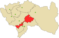 Location of Concepción in the Junín Region | ||
| Country | Peru | |
| Region | Junín | |
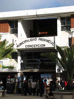
| Capital | Concepción | |
| Government | ||
| • Mayor | Oscar Enrique Berrios Fuentes | |
| Area | ||
| • Total | 3,067.52 km2 (1,184.38 sq mi) | |
| Population (2002 estimate) | ||
| • Total | 71,215 | |
| • Density | 23/km2 (60/sq mi) | |
| UBIGEO | 120201 | |
| Website | www.municoncepcion.gob.pe | |
Concepción Province is one of nine provinces in the Junín Region in central Peru. Its capital is Concepción.
Notable sites include El convento de Ocopa, which contains a vast library and artefacts that were acquired from the first Spanish expeditions to the Peruvian Amazon rainforest.
Geography
The Waytapallana mountain range traverses the province. Some of the highest peaks of the province are listed below:[1]
- Allpa Q'asa
- Anchhi
- Aywin
- Challwayuq
- Chichi Q'asa
- Ch'uspi
- Kawituyuq
- Kimaqucha
- Kimsa Uchku
- Kiswar
- Liwinayuq
- Llant'a Pallaku
- Lasu Pata
- Marayrasu
- Muratayuq
- Pachaqniyuq
- Pinkuylluyuq Punta
- Puma Kusma
- Putkaqucha
- Putkaqucha (Concepción)
- Puywan
- Quchayuq
- Qutu Qutu
- T'illu
- Uma Pukyu
- Utkhulasu
- Utkhu Warqu
- Wamanripayuq
- Warmi Sinqa
- Waytapallana
- Yanaqucha
Political division
The province is divided into seventeen districts (Spanish: distritos, singular: distrito), each of which is headed by a mayor (alcalde):
References
- ↑ escale.minedu.gob.pe/ UGEL map of the Concepción Province (Junín Region)
External links
| |
|---|---|
Coordinates: 11°55′07″S 75°18′46″W / 11.918478°S 75.312889°W
This article is issued from
Wikipedia.
The text is licensed under Creative Commons - Attribution - Sharealike.
Additional terms may apply for the media files.