Colorado State Highway 39
| ||||
|---|---|---|---|---|
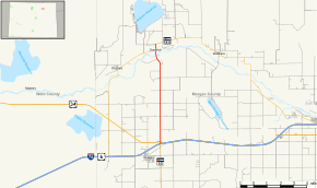 Map of Morgan County in northern Colorado with SH 39 highlighted in red | ||||
| Route information | ||||
| Maintained by CDOT | ||||
| Length | 7.571 mi[1] (12.184 km) | |||
| Location | ||||
| Counties | Morgan | |||
| Highway system | ||||
|
Colorado State Highways
| ||||

Route description
SH 39 runs 7.6 miles (12.2 km), starting at a junction with I-76 near Wiggins, going north across the South Platte River and ending at a junction with SH 144 near Jackson Lake State Park.
Major intersections
The entire route is in Morgan County.
| Location | mi | km | Destinations | Notes | |
|---|---|---|---|---|---|
| | 0.000 | 0.000 | |||
| | 0.328 | 0.528 | |||
| | 7.571 | 12.184 | |||
| 1.000 mi = 1.609 km; 1.000 km = 0.621 mi | |||||
References
- ↑ "Segment list for SH 39". Retrieved 2011-01-21.
External links
This article is issued from
Wikipedia.
The text is licensed under Creative Commons - Attribution - Sharealike.
Additional terms may apply for the media files.