Colorado State Highway 10
| ||||
|---|---|---|---|---|
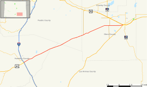 Map of south central Colorado with SH 10 highlighted in red | ||||
| Route information | ||||
| Maintained by CDOT | ||||
| Length | 71.97 mi[1] (115.82 km) | |||
| Major junctions | ||||
| West end |
| |||
| East end |
| |||
| Location | ||||
| Counties | Huerfano, Las Animas, Pueblo, Otero | |||
| Highway system | ||||
|
Colorado State Highways
| ||||

State Highway 10 in the U.S. state of Colorado is a route through the southeast region of the state, connecting Walsenburg, Colorado with La Junta, Colorado.
History
The route was established in the 1920s, when it began at the Utah state line near Dove Creek and went east to Walsenburg on today's Interstate 25. By 1936, a section was added pushing SH 10's terminus east to La Junta. By 1938, the route was corrected in a more straight line and most of the route was paved. The entire route was paved by 1960. The entire section from the Utah border to Walsenburg, the original alignment of the route, was relinquished in 1968.[2]
Major intersections
| County | Location | mi[1] | km | Destinations | Notes | |||
|---|---|---|---|---|---|---|---|---|
| Huerfano | Walsenburg | 0 | 0.0 | |||||
| Las Animas |
No major junctions | |||||||
| Pueblo |
No major junctions | |||||||
| Otero | Hawley | 62.731 | 100.956 | |||||
| La Junta | 71.968 | 115.821 | Eastern terminus | |||||
| 1.000 mi = 1.609 km; 1.000 km = 0.621 mi | ||||||||
References
- 1 2 "Segment list for SH 10". Retrieved 2007-05-12.
- ↑ Salek, Matthew E. "Colorado Routes 1-19". Retrieved 2010-05-26.
External links
This article is issued from
Wikipedia.
The text is licensed under Creative Commons - Attribution - Sharealike.
Additional terms may apply for the media files.