Collinsville, Alabama
| Collinsville, Alabama | |
|---|---|
| Town | |
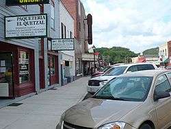 Downtown Collinsville, Alabama | |
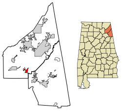 Location of Collinsville in Cherokee County and DeKalb County, Alabama. | |
| Coordinates: 34°15′55″N 85°51′41″W / 34.26528°N 85.86139°W | |
| Country | United States |
| State | Alabama |
| Counties | DeKalb, Cherokee |
| Area[1] | |
| • Total | 3.93 sq mi (10.19 km2) |
| • Land | 3.92 sq mi (10.14 km2) |
| • Water | 0.02 sq mi (0.05 km2) |
| Elevation | 702 ft (214 m) |
| Population (2010) | |
| • Total | 1,983 |
| • Estimate (2017)[2] | 1,969 |
| • Density | 502.81/sq mi (194.15/km2) |
| Time zone | UTC-6 (Central (CST)) |
| • Summer (DST) | UTC-5 (CDT) |
| ZIP code | 35961 |
| Area code(s) | 256 |
| FIPS code | 01-16600 |
| GNIS feature ID | 0150164 |
| Website |
www |
Collinsville is a town in DeKalb and Cherokee counties in the U.S. state of Alabama. It was incorporated in 1887.[3] As of the 2010 census, the population was 1,983.[4] The town is a part of the Gadsden, Alabama Metropolitan Statistical Area.
Collinsville's largest employer is Koch Foods. It is a poultry plant that employees approximately 800 employees.
Geography
Collinsville is located in southern DeKalb County at 34°15'55.555" North, 85°51'41.483" West (34.265432, -85.861523).[5] A small portion extends southeast along Alabama State Route 68 into Cherokee County. The town is located in the Little Wills Valley, between Lookout Mountain to the east and the smaller Big Ridge to the west.
According to the U.S. Census Bureau, the town has a total area of 3.9 square miles (10.2 km2), of which 0.019 square miles (0.05 km2), or 0.44%, is water.[4]
Demographics
| Historical population | |||
|---|---|---|---|
| Census | Pop. | %± | |
| 1880 | 160 | — | |
| 1890 | 367 | 129.4% | |
| 1900 | 524 | 42.8% | |
| 1910 | 673 | 28.4% | |
| 1920 | 793 | 17.8% | |
| 1930 | 892 | 12.5% | |
| 1940 | 957 | 7.3% | |
| 1950 | 1,023 | 6.9% | |
| 1960 | 1,199 | 17.2% | |
| 1970 | 1,300 | 8.4% | |
| 1980 | 1,383 | 6.4% | |
| 1990 | 1,429 | 3.3% | |
| 2000 | 1,644 | 15.0% | |
| 2010 | 1,983 | 20.6% | |
| Est. 2017 | 1,969 | [2] | −0.7% |
| U.S. Decennial Census[6] 2013 Estimate[7] | |||
As of the 2010 census Collinsville had a population of 1,983. The racial and ethnic composition of the population was 44.9% non-Hispanic white, 9.0% black or African American, 1.1% Native American, 0.1% Asian, 2.1% Pacific Islander (all of whom where Guamanian or Chamorro), 36.8% reporting some other race and 3.0% from two or more races. 43.1% of the population was Hispanic or Latino of any race.[8]
As of the census[9] of 2000, there were 1,644 people, 565 households, and 367 families residing in the town. The population density was 465.8 people per square mile (179.8/km2). There were 629 housing units at an average density of 178.2 per square mile (68.8/km2). The racial makeup of the town was 63.32% White, 16.18% Black or African American, 1.52% Native American, 0.85% Asian, 13.99% from other races, and 4.14% from two or more races. 23.48% of the population were Hispanic or Latino of any race.
There were 565 households out of which 29.9% had children under the age of 18 living with them, 40.4% were married couples living together, 18.2% had a female householder with no husband present, and 35.0% were non-families. 29.4% of all households were made up of individuals and 15.2% had someone living alone who was 65 years of age or older. The average household size was 2.62 and the average family size was 3.20.
In the town, the population was spread out with 24.1% under the age of 18, 10.3% from 18 to 24, 24.4% from 25 to 44, 19.2% from 45 to 64, and 22.0% who were 65 years of age or older. The median age was 36 years. For every 100 females, there were 90.9 males. For every 100 females age 18 and over, there were 85.4 males.
The median income for a household in the town was $21,964, and the median income for a family was $27,500. Males had a median income of $20,114 versus $16,635 for females. The per capita income for the town was $13,042. About 22.2% of families and 25.7% of the population were below the poverty line, including 33.3% of those under age 18 and 27.0% of those age 65 or over.
Education
Collinsville Elementary (K-6) and Collinsville High (7-12), home of the Panthers. The CHS football team was the first football team in Dekalb County. The Panthers' first team was in 1920. The schedule in 1920 included a regular season game vs. Jacksonville State University. Collinsville also has a very strong tradition in other sports. For instance, the first All-American in basketball at The University of Alabama, Lindy Hood, was a Collinsville alum.
Collinsville currently competes in Class 2A.
The schools are members of the DeKalb County School System.
Collinsville High School Has Won 2 State Championships
Boys Basketball - 1975 (1A)
Boys Soccer - 2013 (1A-4A)
Climate
The climate in this area is characterized by hot, humid summers and generally mild to cool winters. According to the Köppen Climate Classification system, Collinsville has a humid subtropical climate, abbreviated "Cfa" on climate maps.[10]
Tourism
Collinsville is home to the Collinsville Trade Day, which is held every Saturday. It is estimated that 10,000 people visit the trade day each week, a number which may reach 30,000 in spring.[11] The trade day was originally located outside the city limits, but was annexed in 2004.[12]
References
- ↑ "2017 U.S. Gazetteer Files". United States Census Bureau. Retrieved Jul 7, 2018.
- 1 2 "Population and Housing Unit Estimates". Retrieved March 24, 2018.
- ↑ "Collinsville | Encyclopedia of Alabama". Encyclopedia of Alabama. Retrieved 2018-06-07.
- 1 2 "Geographic Identifiers: 2010 Demographic Profile Data (G001): Collinsville town, Alabama". U.S. Census Bureau, American Factfinder. Retrieved June 3, 2014.
- ↑ "US Gazetteer files: 2010, 2000, and 1990". United States Census Bureau. 2011-02-12. Retrieved 2011-04-23.
- ↑ "U.S. Decennial Census". Census.gov. Archived from the original on May 12, 2015. Retrieved June 6, 2013.
- ↑ "Annual Estimates of the Resident Population: April 1, 2010 to July 1, 2013". Retrieved June 3, 2014.
- ↑ 2010 profile of population and housing characteristics for Collinsville from the US Census
- ↑ "American FactFinder". United States Census Bureau. Archived from the original on 2013-09-11. Retrieved 2008-01-31.
- ↑ "Collinsville, Alabama Köppen Climate Classification (Weatherbase)". Weatherbase. Retrieved 2018-06-07.
- ↑ "Gadsden Times - Google News Archive Search". news.google.com. Retrieved 2018-06-07.
- ↑ "Gadsden Times - Google News Archive Search". news.google.com. Retrieved 2018-06-07.
External links
Coordinates: 34°15′56″N 85°51′41″W / 34.265432°N 85.861523°W
Municipalities and communities of Cherokee County, Alabama, United States | ||
|---|---|---|
| City |  | |
| Towns | ||
| CDPs | ||
| Unincorporated communities | ||
| Ghost town | ||
| Footnotes | ‡This populated place also has portions in an adjacent county or counties | |
Municipalities and communities of DeKalb County, Alabama, United States | ||
|---|---|---|
| Cities |  | |
| Towns | ||
| Unincorporated communities | ||
| Ghost towns | ||
| Footnotes | ‡This populated place also has portions in an adjacent county or counties | |