Colle Umberto
| Colle Umberto | |
|---|---|
| Comune | |
| Comune di Colle Umberto | |
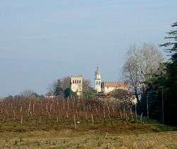 View with campanile and Lucheschi Castle | |
 Colle Umberto Location of Colle Umberto in Italy | |
| Coordinates: 45°57′N 12°21′E / 45.950°N 12.350°ECoordinates: 45°57′N 12°21′E / 45.950°N 12.350°E | |
| Country | Italy |
| Region | Veneto |
| Province | Treviso (TV) |
| Frazioni |
San Martino di Colle Umberto telephone = 0438 |
| Government | |
| • Mayor | Edoardo Scarpis |
| Area | |
| • Total | 13.6 km2 (5.3 sq mi) |
| Elevation | 144 m (472 ft) |
| Population (30 June 2017)[1] | |
| • Total | 5,081 |
| • Density | 370/km2 (970/sq mi) |
| Demonym(s) | Collumbertesi |
| Time zone | UTC+1 (CET) |
| • Summer (DST) | UTC+2 (CEST) |
| Postal code | 31014 |
| Website | Official website |
Colle Umberto is a comune (municipality) in the Province of Treviso in the Italian region Veneto, located about 60 kilometres (37 mi) north of Venice and about 30 kilometres (19 mi) north of Treviso.
Colle Umberto borders the following municipalities: Cappella Maggiore, Conegliano, Cordignano, Godega di Sant'Urbano, San Fior, Vittorio Veneto.
The town's most visited place is the Villa Verecondi Scortecci owned by an old upper-class Venetian family.
San Martino
The [[frazione] of San Martino was the birthplace of Ottavio Bottecchia, the first Italian to win the Tour de France in both 1924 and 1925, but he died mysteriously at the height of career during a training ride in Friuli, at Trasaghis. There is a local move to create a museum to him.
Twin towns
The town is twinned with the following:
References
External links
