Coffee Springs, Alabama
| Coffee Springs, Alabama | |
|---|---|
| Town | |
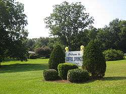 Welcome sign in Coffee Springs | |
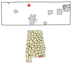 Location of Coffee Springs in Geneva County, Alabama. | |
| Coordinates: 31°10′0″N 85°54′38″W / 31.16667°N 85.91056°W | |
| Country | United States |
| State | Alabama |
| County | Geneva |
| Area[1] | |
| • Total | 0.80 sq mi (2.06 km2) |
| • Land | 0.78 sq mi (2.03 km2) |
| • Water | 0.01 sq mi (0.03 km2) |
| Elevation | 213 ft (65 m) |
| Population (2010) | |
| • Total | 228 |
| • Estimate (2017)[2] | 226 |
| • Density | 288.27/sq mi (111.32/km2) |
| Time zone | UTC-6 (Central (CST)) |
| • Summer (DST) | UTC-5 (CDT) |
| ZIP code | 36318 |
| Area code(s) | 334 |
| FIPS code | 01-16240 |
| GNIS feature ID | 0116355 |
Coffee Springs is a town in Geneva County, Alabama, United States. It was incorporated in 1900, and it is considered to be a part of the Dothan, Alabama Metropolitan Statistical Area. At the 2010 census the population was 228, down from 251.
Coffee Springs has been noted for its unusual place name.[3]
Geography
Coffee Springs is located at 31°10′0″N 85°54′38″W / 31.16667°N 85.91056°W (31.166736, -85.910634).[4]
According to the U.S. Census Bureau, the town has a total area of 0.8 square miles (2.1 km2), of which 0.8 square miles (2.1 km2) is land and 1.25% is water.
Demographics
| Historical population | |||
|---|---|---|---|
| Census | Pop. | %± | |
| 1910 | 503 | — | |
| 1920 | 312 | −38.0% | |
| 1930 | 258 | −17.3% | |
| 1940 | 196 | −24.0% | |
| 1950 | 173 | −11.7% | |
| 1960 | 205 | 18.5% | |
| 1970 | 329 | 60.5% | |
| 1980 | 339 | 3.0% | |
| 1990 | 294 | −13.3% | |
| 2000 | 251 | −14.6% | |
| 2010 | 228 | −9.2% | |
| Est. 2017 | 226 | [2] | −0.9% |
| U.S. Decennial Census[5] 2013 Estimate[6] | |||
As of the census[7] of 2000, there were 251 people, 108 households, and 74 families residing in the town. The population density was 320.3 people per square mile (124.2/km2). There were 128 housing units at an average density of 163.3 per square mile (63.4/km2). The racial makeup of the town was 93.23% White, 3.98% Black or African American, and 2.79% from two or more races.
There were 108 households out of which 17.6% had children under the age of 18 living with them, 57.4% were married couples living together, 12.0% had a female householder with no husband present, and 30.6% were non-families. 24.1% of all households were made up of individuals and 15.7% had someone living alone who was 65 years of age or older. The average household size was 2.32 and the average family size was 2.77.
In the town, the population was spread out with 16.7% under the age of 18, 8.0% from 18 to 24, 18.3% from 25 to 44, 36.3% from 45 to 64, and 20.7% who were 65 years of age or older. The median age was 50 years. For every 100 females, there were 78.0 males. For every 100 females age 18 and over, there were 77.1 males.
The median income for a household in the town was $26,477, and the median income for a family was $30,000. Males had a median income of $28,750 versus $15,833 for females. The per capita income for the town was $12,393. About 13.8% of families and 17.1% of the population were below the poverty line, including 15.4% of those under the age of eighteen and 25.3% of those sixty five or over.
Climate
The climate in this area is characterized by hot, humid summers and generally mild to cool winters. According to the Köppen Climate Classification system, Coffee Springs has a humid subtropical climate, abbreviated "Cfa" on climate maps. [8]
Notable person
- Jim Bowdoin, professional American football player who played guard for seven seasons for the Green Bay Packers, Brooklyn Dodgers, New York Giants, and Portsmouth Spartans
References
- ↑ "2017 U.S. Gazetteer Files". United States Census Bureau. Retrieved Jul 7, 2018.
- 1 2 "Population and Housing Unit Estimates". Retrieved March 24, 2018.
- ↑ Thompson, George E. (1 July 2009). You Live Where?: Interesting and Unusual Facts about where We Live. iUniverse. p. 2. ISBN 978-1-4401-3421-0.
- ↑ "US Gazetteer files: 2010, 2000, and 1990". United States Census Bureau. 2011-02-12. Retrieved 2011-04-23.
- ↑ "U.S. Decennial Census". Census.gov. Archived from the original on May 12, 2015. Retrieved June 6, 2013.
- ↑ "Annual Estimates of the Resident Population: April 1, 2010 to July 1, 2013". Retrieved June 3, 2014.
- ↑ "American FactFinder". United States Census Bureau. Archived from the original on 2013-09-11. Retrieved 2008-01-31.
- ↑ Climate Summary for Coffee Springs, Alabama
Coordinates: 31°10′00″N 85°54′38″W / 31.166736°N 85.910634°W
Municipalities and communities of Geneva County, Alabama, United States | ||
|---|---|---|
| Cities | 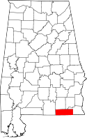 | |
| Towns | ||
| CDP | ||
| Unincorporated communities | ||
| Footnotes | ‡This populated place also has portions in an adjacent county or counties | |