Cochrane Road (Hamilton, Ontario)
Cochrane Road is a two-way Lower City collector road in Hamilton, Ontario, Canada. It starts off at the Queenston Traffic Circle and travels South between the Bartonville and Glenview neighbourhoods right through to the Rosedale neighbourhood where it ends at Greenhill Avenue in front of Rosedale Park. From this point onwards the road is now known as Whitehouse Road and weaves its way through King's Forest Golf Course and King's Forest Park.
History
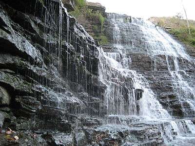
Albion Falls, a classical/cascade waterfall, and one of Hamilton's 100+ waterfalls, can be found here at the back-end of King's Forest Park. A nearby parking lot was removed when the construction of the nearby Red Hill Valley Parkway started. A parking lot at Mountain Brow Road above the falls for 50+ cars is still available for visitors.[1] Up to the early 1900s a small vibrant village called Albion Mills was found here. The rocks from Albion Falls area were used to construct the Rock Garden at the Royal Botanical Gardens. Another waterfall can be found nearby, northwest of Albion Falls called, Buttermilk Falls. Not too far off and just East of the newly built Red Hill Valley Parkway at the Glendale Golf & Country Club is another waterfall called, Glendale Falls on Mount Albion Road.[2][3]
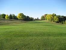
King's Forest Golf Club was established in 1974 and is run by the city of Hamilton. The Red Hill Creek and many fair-sized ponds come into play.[4] Credited as being one of the very best municipally owned courses in Canada.[5]
Landmarks

Note: Listing of Landmarks from North to South.
- Queenston Traffic Circle
- Bartonville Cemetery
- Canadian Pacific Railway line
- Rosedale Park
- Rosedale Arena
- Red Hill Valley Trail (East of Arena)
- Red Hill Valley Parkway (East of Arena/Park)
- Escarpment Rail Trail (abandoned railway path)
- Chippawa Rail Trail (abandoned railway path)
- King's Forest Park
- King's Forest Golf Course
- Bruce Trail (West of golf course)
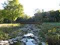
- Red Hill Creek (East of golf course)
- Oak Knoll Park
- Buttermilk Falls (backend of King's Forest Park)
- Albion Falls (backend of King's Forest Park)
- Glendale Falls (backend of King's Forest Park)
Communities

Note: Listing of neighbourhoods from North to South [6]
- Bartonville/Glenview, Cochrane Road is the division between these two neighbourhoods.
- Rosedale
Intersecting streets
Note: Listing of streets from North to South.
- Main Street East
- Queenston Road
- King Street East
- Lawrence Road
Parallel streets
Note: Listing of streets from West to East.
- Victoria Avenue, North, South
- Wentworth Street, North, South
- Sherman Avenue, North, South
- Gage Avenue, North, South
- Ottawa Street, North, South
- Kenilworth Avenue, North, South
- Cochrane Road
- Parkdale Avenue, North, South
- Red Hill Valley Parkway
- Nash Road, North, South
- Woodward Avenue
- Centennial Parkway, North, South
- Lake Avenue, North, Drive
Images
 King's Forest Park, looking South
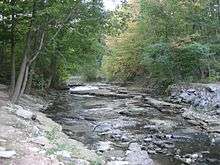 Red Hill Creek, King's Forest Park
 Red Hill Creek, King's Forest Park
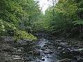 Red Hill Creek, King's Forest Park
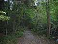 Bruce Trail, King's Forest Park
 Bruce Trail, King's Forest Park
 Red Hill Creek, King's Forest Park
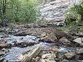 Red Hill Creek, King's Forest Park
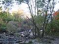 Albion Falls, King's Forest Park
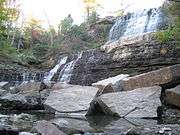 Albion Falls, King's Forest Park
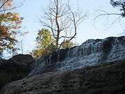 Albion Falls, King's Forest Park
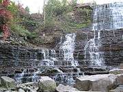 Albion Falls, King's Forest Park
See also
References
- ↑ "Albion Falls". (www.gowaterfalling.com). Retrieved 2007-04-18.
- ↑ "Albion Falls". Hamilton Conservation Authority. Archived from the original on 2007-04-07. Retrieved 2007-04-18.
- ↑ "Buttermilk Falls". Hamilton Conservation Authority. Archived from the original on 2007-04-08. Retrieved 2007-04-18.
- ↑ "King's Forest Golf Club". OntGolf.ca. Retrieved 2007-04-18.
- ↑ "King's Forest Golf Club". GolfCanada.com. Retrieved 2007-04-18.
- ↑ "Hamilton Neighbourhood Boundaries, (map.hamilton.ca)" (PDF). Archived from the original (PDF) on 2007-09-27. Retrieved 2007-05-11.
- MapArt Golden Horseshoe Atlas - Page 648 - Grids G18, H18, J18, K18