Cobar Airport
| Cobar Airport | |||||||||||||||
|---|---|---|---|---|---|---|---|---|---|---|---|---|---|---|---|
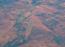 Aerial image, 6 March 2009 | |||||||||||||||
| Summary | |||||||||||||||
| Airport type | Public | ||||||||||||||
| Operator | Cobar Shire Council | ||||||||||||||
| Serves | Cobar, New South Wales, Australia | ||||||||||||||
| Elevation AMSL | 724 ft / 221 m | ||||||||||||||
| Coordinates | 31°32′18″S 145°47′36″E / 31.53833°S 145.79333°ECoordinates: 31°32′18″S 145°47′36″E / 31.53833°S 145.79333°E | ||||||||||||||
| Map | |||||||||||||||
|
YCBA Location in New South Wales | |||||||||||||||
| Runways | |||||||||||||||
| |||||||||||||||
|
Sources: Enroute Supplement Australia from Airservices Australia[1] | |||||||||||||||
Cobar Airport (IATA: CAZ, ICAO: YCBA) is an airport located 3 nautical miles (5.6 km; 3.5 mi) southwest[1] of Cobar, a town in the Australian state of New South Wales.
Facilities
The airport is 724 ft (221 m) above mean sea level.[1] It has two runways: 05/23 with an asphalt surface measuring 1,519 by 30 metres (4,984 ft × 98 ft) and 17/35 with a clay surface measuring 1,221 by 30 metres (4,006 ft × 98 ft).[1]
Airlines and destinations
| Airlines | Destinations |
|---|---|
| Regional Express Airlines operated by Air Link | Dubbo[2] |
See also
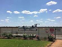
Beechcraft 1900D of Air Link parked on the apron at Cobar airport
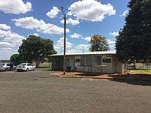
Cobar airport terminal building
References
- 1 2 3 4 YCBA – COBAR (PDF). AIP En Route Supplement from Airservices Australia, effective 01 March 2018
- ↑ http://www.regionalexpress.com.au/MediaRelease/Files/465_MR20150817-AirLinkAnnouncesCobarServices.pdf
External links
This article is issued from
Wikipedia.
The text is licensed under Creative Commons - Attribution - Sharealike.
Additional terms may apply for the media files.