Coatzacoalcos River
| Coatzacoalcos | |
| River | |
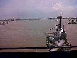 Approaching the mouth of the river from the Gulf of Mexico the city of Coatzacoalcos lies to starboard Allende to port, 30 August 2011 | |
| Name origin: "where serpent hides" (Nahuatl) | |
| Country | |
|---|---|
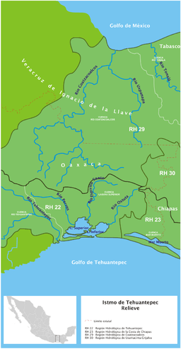
| States | Oaxaca, Veracruz |
| Region | Isthmus of Tehuantepec |
| Tributaries | |
| - left | Sarabia, Jaltepec |
| - right | El Corte, Uxpanapa |
| Cities | Matías Romero, Minatitlán, Nanchital, Coatzacoalcos |
| Source | |
| - coordinates | 16°56′44″N 94°37′1″W / 16.94556°N 94.61694°W |
| Mouth | |
| - elevation | 0 m (0 ft) |
| - coordinates | 18°9′56″N 94°24′50″W / 18.16556°N 94.41389°WCoordinates: 18°9′56″N 94°24′50″W / 18.16556°N 94.41389°W |
| Length | 325 km (202 mi) |
| Basin | 17,563 km2 (6,781 sq mi) |
| Discharge | |
| - average | 1,163 m3/s (41,071 cu ft/s) |
 | |
| [1] | |
The Coatzacoalcos is a large river that feeds mainly the south part of the state of Veracruz; it originates in the Sierra de Niltepec and crosses the state of Oaxaca in the region of the Isthmus of Tehuantepec, flowing for 325 kilometres (202 miles)[1][2] toward the Gulf of Mexico. Tributaries include El Corte, Sarabia, Jaltepec, Chalchijalpa, El Chiquito, Uxpanapa, and Calzadas. The merging of all these rivers creates one of the largest current flows in the entire region. Two-thirds of the streams are navigable.
Juan de Grijalva's 1518 expedition discovered the river.[3]:34 Hernan Cortes sent Diego de Ordaz to explore the river as a possible port.[3]:266–268
Legend
According to legend, the Mesoamerican god Quetzalcoatl was aboard a raft made of a serpent skin and navigated until getting lost into the horizon. Ever since, the river has been known as Coatzacoalcos, which means “the place where the serpent hides” in Nahuatl.[4]
Port
The city of Coatzacoalcos, at the river's mouth, is one of the most commercial and industrialized ports, considered the third most important in the Gulf of Mexico, offering one of the most important means of transportation for an international commerce whose products are important to the local industrial farming business, forestry, and commerce in general for the Isthmus of Tehuantepec.
Pollution
The Coatzacoalcos is also among the world's most contaminated rivers, partly because of the lack of environmental laws protecting the public water.[5] According to the Mexican Center of Environmental Law (CEMDA) the biggest polluting body is the petrochemical industry of Mexico Pemex.[6]
See also
| Wikimedia Commons has media related to Coatzacoalcos River. |
References
- 1 2 "Estadísticas por tema" (in Spanish). INEGI. Retrieved 21 September 2011.
- ↑ Coatzacoalcos River. The Columbia Gazetteer of North America. 2000 Archived 2 July 2004 at the Wayback Machine.
- 1 2 Diaz, B., 1963, The Conquest of New Spain, London: Penguin Books, ISBN 0140441239
- ↑ Wimmer, Alexis. "DICTIONNAIRE de la langue NAHUATL CLASSIQUE" (in French). Retrieved 22 September 2011.
- ↑ Peter M. Garber The Mexico-US Free Trade Agreement, 19 January 1994
- ↑ Oil Spill in Coatzacoalcos River and Beach. Veracruz, Republic of Mexico, 22 December 2004