Coats Bend, Alabama
| Coats Bend, Alabama | |
|---|---|
| Census-designated place | |
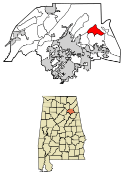 Location of Coats Bend in Etowah County, Alabama. | |
 Coats Bend Location of Coats Bend in Etowah County, Alabama. | |
| Coordinates: 34°04′39″N 85°52′27″W / 34.07750°N 85.87417°WCoordinates: 34°04′39″N 85°52′27″W / 34.07750°N 85.87417°W | |
| Country | United States |
| State | Alabama |
| County | Etowah |
| Area[1] | |
| • Total | 8.58 sq mi (22.21 km2) |
| • Land | 8.55 sq mi (22.14 km2) |
| • Water | 0.03 sq mi (0.07 km2) |
| Elevation | 617 ft (188 m) |
| Population (2010)[2] | |
| • Total | 1,657 |
| • Estimate (2016)[3] | N/A |
| Time zone | UTC-6 (Central (CST)) |
| • Summer (DST) | UTC-5 (CDT) |
| Area code(s) | 256 & 938 |
| GNIS feature ID | 2582669[4] |
Coats Bend is a census-designated place in Etowah County, Alabama, United States. Its population was 1,394 as of the 2010 census.[2] A post office was established in 1878 and was in operation until 1903.[5]
Demographics
| Historical population | |||
|---|---|---|---|
| Census | Pop. | %± | |
| U.S. Decennial Census[6] | |||
References
- ↑ "2016 U.S. Gazetteer Files". United States Census Bureau. Retrieved Jul 17, 2017.
- 1 2 "American FactFinder". United States Census Bureau. Archived from the original on 2013-09-11. Retrieved 2011-05-14.
- ↑ "Population and Housing Unit Estimates". Retrieved June 9, 2017.
- ↑ "Coats Bend Census Designated Place". Geographic Names Information System. United States Geological Survey.
- ↑ "Etowah County". Jim Forte Postal History. Archived from the original on 6 October 2014. Retrieved 25 December 2014.
- ↑ "Census of Population and Housing". Census.gov. Retrieved June 4, 2016.
Municipalities and communities of Etowah County, Alabama, United States | ||
|---|---|---|
| Cities | 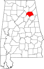 | |
| Towns | ||
| CDPs | ||
| Unincorporated communities | ||
| Footnotes | ‡This populated place also has portions in an adjacent county or counties | |
This article is issued from
Wikipedia.
The text is licensed under Creative Commons - Attribution - Sharealike.
Additional terms may apply for the media files.