Clot de la Hount
| Clot de la Hount | |
|---|---|
 centre-left | |
| Highest point | |
| Elevation | 3,289 m (10,791 ft) [1] |
| Prominence | 40 metres (130 ft) |
| Listing | List of Pyrenean three-thousanders |
| Coordinates | 42°46′23″N 0°08′59″E / 42.77306°N 0.14972°ECoordinates: 42°46′23″N 0°08′59″E / 42.77306°N 0.14972°E [1] |
| Geography | |
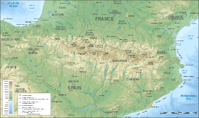 Clot de la Hount Location in the Pyrenees | |
| Location | France — Spain |
| Région Communauté |
Midi-Pyrénées Aragon |
| Département Province |
Hautes-Pyrénées Huesca |
| Parent range | Vignemale Massif (Pyrenees) |
| Climbing | |
| Easiest route | From Glacier d'Ossoue |
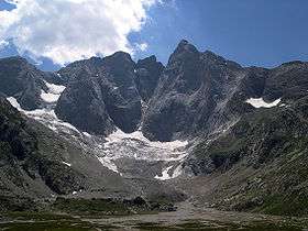
The Clot de la Hount or pic du clot de la Hount is a summit of the Pyrenees, located on the Franco-Spanish border in the Vignemale Massif, of which it is the second highest summit in the range, at 3,289 m, after Pique Longue (3,298 m).
Toponymy
The Clot de la Hount is a term coined by shepherds for the area near the bottom of the peak.
Hount refers to a spring source which flows intermittently (Hount meaning eye, or a passage that is sometimes open, sometimes shut).
Clot means either a ledge or a pen.
Topography
The French side is located in the Hautes-Pyrénées department, between Cauterets and Gavarnie, in the arrondissement of Argelès-Gazost which lies in the Pyrenees National Park. The southern Spanish side is in the Natural Reserve of Ordesa-Viñamala, in Torla territory, Huesca province.
References
- 1 2 Source : Géoportail