Clearfield Township, Griggs County, North Dakota
| Clearfield Township, North Dakota | |
|---|---|
| Township | |
 Clearfield Township, North Dakota Location within the state of North Dakota | |
| Coordinates: 47°27′51″N 98°17′50″W / 47.46417°N 98.29722°WCoordinates: 47°27′51″N 98°17′50″W / 47.46417°N 98.29722°W | |
| Country | United States |
| State | North Dakota |
| County | Griggs |
| Area | |
| • Total | 36.0 sq mi (93.2 km2) |
| • Land | 35.4 sq mi (91.6 km2) |
| • Water | 0.6 sq mi (1.6 km2) |
| Elevation | 1,457 ft (444 m) |
| Population (2000) | |
| • Total | 49 |
| • Density | 1.4/sq mi (0.5/km2) |
| Time zone | UTC-6 (Central (CST)) |
| • Summer (DST) | UTC-5 (CDT) |
| Area code(s) | 701 |
| FIPS code | 38-14340[1] |
| GNIS feature ID | 1036644[2] |
Clearfield Township is a township in Griggs County, North Dakota, United States. At the 2000 census, its population was 49, 44 of whom were over 18.
References
- ↑ "American FactFinder". United States Census Bureau. Archived from the original on 2013-09-11. Retrieved 2008-01-31.
- ↑ "US Board on Geographic Names". United States Geological Survey. 2007-10-25. Retrieved 2008-01-31.
Municipalities and communities of Griggs County, North Dakota, United States | ||
|---|---|---|
| Cities | 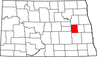 | |
| Townships |
| |
| CDPs | ||
| Unincorporated communities | ||
This article is issued from
Wikipedia.
The text is licensed under Creative Commons - Attribution - Sharealike.
Additional terms may apply for the media files.