Clay Hill, Alabama
| Clay Hill, Alabama | |
|---|---|
| Unincorporated community | |
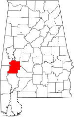
 Clay Hill, Alabama Location within the state of Alabama  Clay Hill, Alabama Clay Hill, Alabama (the US) | |
| Coordinates: 32°0′59.51″N 87°45′2.02″W / 32.0165306°N 87.7505611°W | |
| Country | United States |
| State | Alabama |
| County | Marengo |
| Elevation | 285 ft (87 m) |
| Time zone | UTC-6 (Central (CST)) |
| • Summer (DST) | UTC-5 (CDT) |
| Area code(s) | 334 |
Clay Hill, also spelled Clayhill, is an unincorporated community in Marengo County, Alabama, United States.[1] Clay Hill was established prior to the American Civil War. It had a post office at one time, but it no longer exists.[2]
Geography
Clay Hill is located at 32°01′00″N 87°45′02″W / 32.01653°N 87.75056°WCoordinates: 32°01′00″N 87°45′02″W / 32.01653°N 87.75056°W and has an elevation of 285 feet (87 m).[1]
References
This article is issued from
Wikipedia.
The text is licensed under Creative Commons - Attribution - Sharealike.
Additional terms may apply for the media files.