Claut
| Claut | |
|---|---|
| Comune | |
| Comune di Claut | |
 Claut Location of Claut in Italy | |
| Coordinates: 46°16′N 12°31′E / 46.267°N 12.517°E | |
| Country | Italy |
| Region | Friuli-Venezia Giulia |
| Province | Pordenone (PN) |
| Frazioni | Cellino di sopra, Cellino di sotto, Contròn, Creppi, Lesis, Matàn, Pinedo, Stoc, Vit |
| Government | |
| • Mayor | Gionata Sturam |
| Area | |
| • Total | 166.3 km2 (64.2 sq mi) |
| Elevation | 613 m (2,011 ft) |
| Population (31 December 2010)[1] | |
| • Total | 1,027 |
| • Density | 6.2/km2 (16/sq mi) |
| Demonym(s) | Clautani or Clautàns |
| Time zone | UTC+1 (CET) |
| • Summer (DST) | UTC+2 (CEST) |
| Postal code | 33080 |
| Dialing code | 0427 |
| Website | Official website |
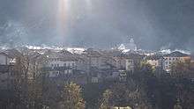
the town
Claut (Western Friulian: Cjolt) is a comune (municipality) in the Province of Pordenone in the Italian region Friuli-Venezia Giulia, located about 120 kilometres (75 mi) northwest of Trieste and about 35 kilometres (22 mi) northwest of Pordenone.
Claut borders the following municipalities: Barcis, Chies d'Alpago, Cimolais, Erto e Casso, Forni di Sopra, Forni di Sotto, Frisanco, Pieve d'Alpago, Tramonti di Sopra.
People
References
External links
This article is issued from
Wikipedia.
The text is licensed under Creative Commons - Attribution - Sharealike.
Additional terms may apply for the media files.