Claritas Fossae
 Claritas Fossae as seen by HiRISE. Note the steep scarp. | |
| Coordinates | 31°30′S 104°06′W / 31.5°S 104.1°WCoordinates: 31°30′S 104°06′W / 31.5°S 104.1°W |
|---|---|
Claritas Fossae is a group of troughs in the Phoenicis Lacus and Thaumasia quadrangles of Mars, located at 31.5 S and 104.1 W. The structure is 2,050.0 km long and was named after a classical albedo feature name.[1]
Long narrow depressions on Mars are called fossae. This term is derived from Latin; therefore fossa is singular and fossae is plural.[2] Troughs form when the crust is stretched until it breaks. The stretching can be due to the large weight of a nearby volcano. Fossae/pit craters are common near volcanoes in the Tharsis and Elysium regions.[3] A trough often has two breaks with a middle section moving down, leaving steep cliffs along the sides; such a trough is called a graben.[4]
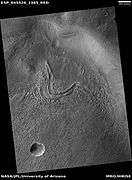 Curved ridge that probably was formed by glacier, as seen by HiRISE under HiWish program
See also
References
- ↑ http://planetarynames.wr.usgs.gov
- ↑ http://www.marsartgallery.com/marsnames.html
- ↑ Skinner, J., L. Skinner, and J. Kargel. 2007. Re-assessment of Hydrovolcanism-based Resurfacing within the Galaxias Fossae Region of Mars. Lunar and Planetary Science XXXVIII (2007)
- ↑ http://hirise.lpl.arizona.edu/PSP_008641_2105
This article is issued from
Wikipedia.
The text is licensed under Creative Commons - Attribution - Sharealike.
Additional terms may apply for the media files.