Wayford
| Wayford | |
|---|---|
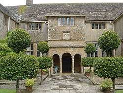 Wayford Manor House | |
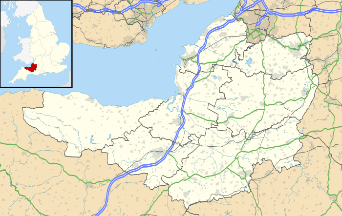 Wayford Wayford shown within Somerset | |
| Population | 114 (2011)[1] |
| OS grid reference | ST405065 |
| District | |
| Shire county | |
| Region | |
| Country | England |
| Sovereign state | United Kingdom |
| Post town | CREWKERNE |
| Postcode district | TA18 |
| Dialling code | 01460 |
| Police | Avon and Somerset |
| Fire | Devon and Somerset |
| Ambulance | South Western |
| EU Parliament | South West England |
| UK Parliament | |
Wayford is a village and civil parish on the River Axe, 3 miles (5 km) south-west of Crewkerne, in the South Somerset district of Somerset, England. The parish contains the hamlets of Oathill and Clapton.
History
The parish was part of the hundred of Crewkerne.[2]
Wayford Manor House was rebuilt around 1600 by Charles Daubeney, probably with William Arnold as master mason. The north wing was completed by Sir Ernest George in 1900.[3] Wayford Woods, close to the house, has an ornamental lake and is known for the large number of fairy doors it used to have.[4][5][6]
Clapton Mill is a former watermill located in the hamlet of Clapton, Wayford, Somerset, England. The existing mill dates back to the 18th century, but was extensively rebuilt in 1864. An earlier mill has existed on the same site since the 13th century.[7][8] The mill, along with its aqueduct, has been Grade II* Listed since 1987, primarily for the surviving machinery which dates back to the 19th century rebuild.[9]
Governance
The parish council has responsibility for local issues, including setting an annual precept (local rate) to cover the council’s operating costs and producing annual accounts for public scrutiny. The parish council evaluates local planning applications and works with the local police, district council officers, and neighbourhood watch groups on matters of crime, security, and traffic. The parish council's role also includes initiating projects for the maintenance and repair of parish facilities, as well as consulting with the district council on the maintenance, repair, and improvement of highways, drainage, footpaths, public transport, and street cleaning. Conservation matters (including trees and listed buildings) and environmental issues are also the responsibility of the council.
The village falls within the Non-metropolitan district of South Somerset, which was formed on 1 April 1974 under the Local Government Act 1972, having previously been part of Chard Rural District.[10] The district council is responsible for local planning and building control, local roads, council housing, environmental health, markets and fairs, refuse collection and recycling, cemeteries and crematoria, leisure services, parks, and tourism.
Somerset County Council is responsible for running the largest and most expensive local services such as education, social services, libraries, main roads, public transport, policing and fire services, trading standards, waste disposal and strategic planning.
It is also part of the[10] county constituency represented in the House of Commons of the Parliament of the United Kingdom. It elects one Member of Parliament (MP) by the first past the post system of election, and part of the South West England constituency of the European Parliament which elects seven MEPs using the d'Hondt method of party-list proportional representation.
Religious sites
The Church of St Michael dates from the 13th century and has been designated by English Heritage as a Grade II* listed building.[11]
References
- ↑ "South Somerset population estimates for 2002" (PDF). Somerset County Council. Archived from the original (PDF) on 21 November 2009. Retrieved 27 December 2009.
- ↑ "Somerset Hundreds". GENUKI. Retrieved 8 October 2011.
- ↑ "Wayford Manor House". Images of England. Retrieved 2008-02-02.
- ↑ "'Fairy control' to halt tiny doors in Somerset woods" (retrieved 4 March 2015)
- ↑ Morris, Steven (4 March 2015). "Fairies' woodland homes face planning control". Guardian. Retrieved 6 March 2015.
- ↑ Morris, Steven, 2015 "Disenchanted Woodland Trustees Banish Fairy Doors," The Guardian, 23 August 2015, p. 22.
- ↑ "Somerset: A Portrait in Colour - Robin Bush - Google Books". Books.google.co.uk. Retrieved 2018-08-14.
- ↑ http://www.heritagegateway.org.uk/Gateway/Results_Single.aspx?uid=54671&resourceID=100
- ↑ "CLAPTON MILL (LOCKYER AND SON), WITH AQUEDUCT TO NORTH EAST, West Crewkerne - 1056856". Historic England. 1987-12-18. Retrieved 2018-08-14.
- 1 2 A Vision of Britain Through Time : Chard Rural District Archived 23 March 2012 at the Wayback Machine.
- ↑ "Church of St Michael". Images of England. Retrieved 2008-02-02.
External links
![]()