Clachnaben
| Clachnaben | |
|---|---|
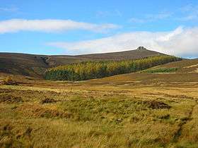 Clachnaben from Glen Dye | |
| Highest point | |
| Elevation | 589 m (1,932 ft) |
| Prominence | c. 54 m |
| Listing | Marilyn |
| Naming | |
| Translation | Rock of the Hill (Gaelic) |
| Geography | |
| Location | Aberdeenshire, Scotland |
| OS grid | NO616865 |
| Topo map | OS Landranger 45 |
Clachnaben (archaically "Cloch-na'bain"; Scottish Gaelic: "Clach na Beinne") is a 589-metre hill in Glen Dye, Aberdeenshire, Scotland.[1] It is a distinctive hill visible from many points on Lower Deeside and is topped with a large granite tor.[2] Clachnaben is the war cry of Clan Strachan.
Geography
A popular walk starts at the car park on the Cairn O' Mounth (Banchory–Fettercairn) road, 10 kilometres south of Banchory. Popularity has caused some erosion on the old steep path which climbs this hill directly; however, efforts have been made to stabilise the erosion.[3] A new improved path takes an easier and less direct route from Millar's Bog to the summit.[4] There are views to Mount Battock, Lochnagar and Bennachie.
The granite tor provides some rock climbing. An annual fell race is run on the hill.
Gallery
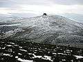 Clachnaben from Mount Shade
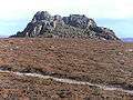 View from below
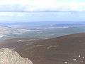 View from the top
References
- ↑ Jim Maison, "Pathway to wisdom in the hills", Leopard Magazine, 48
|access-date=requires|url=(help) - ↑ Watson, Adam (1992). Cairngorms: Locahnagar and the Mounth. Scottish Mountaineering Club. pp. 235–6. ISBN 0-907521-39-8.
- ↑ "Royal Deeside : Clachnaben". Deeside Piper. Retrieved 2007-05-22.
- ↑ VisitScotland. "Clachnaben". Archived from the original on 5 February 2012. Retrieved 2007-03-24.