Ciudad Obregón
| Ciudad Obregón | ||
|---|---|---|
| City | ||
| ||
|
Ciudad Obregón Location of Ciudad Obregon in Mexico | ||
| Coordinates: 27°29′21″N 109°56′06″W / 27.48917°N 109.93500°W | ||
| Country |
| |
| State | Sonora | |
| Municipality | Cajeme | |
| Founded | 1927 | |
| Government | ||
| • Type | Ayuntamiento | |
| • Municipal President | Sergio Pablo Mariscal Alvarado | |
| Elevation | 40 m (130 ft) | |
| Population (2010) | ||
| • Total | 405,000 | |
| Demonym(s) | Obregonense | |
| Time zone | UTC-7 (MST) | |
| • Summer (DST) | UTC-7 (no DST/PDT) | |
| ZIP code | 85000 - 85059 | |
| Area code(s) | 644, | |
| Website | http://www.obregon.gob.mx/ | |

Ciudad Obregón (Spanish pronunciation: [sjuˈðað oβɾeˈɣon]) is the second largest city in the northern Mexican state of Sonora and named for Sonoran revolutionary general and president of Mexico, Álvaro Obregón. It is situated 525 km (326 mi) south of the state's northern border with the U.S. state of Arizona. It is also the municipal seat of Cajeme municipality, located in the Yaqui Valley.
History
The city, previously named Cajeme, takes its name from Mexican Revolutionary Álvaro Obregón, a native of nearby Huatabampo, Sonora. Álvaro Obregón became president of Mexico after the Revolution and initiated an "agricultural revolution" in the Yaqui Valley, introducing modern agricultural techniques and making this valley one of the most prosperous agricultural regions in the country. Renowned U.S. agronomist Dr. Norman Borlaug, the architect of the "Green Revolution" worked here after successful developments in increasing the resistance of wheat. For his efforts he was later awarded the Nobel Prize.
Climate
Ciudad Obregón has a desert climate (Köppen BWh) featuring long, extremely hot summers and short, warm winters with cool mornings. It is frequent that in summer the temperature reach 40 °C (104.0 °F) or more, with overnight lows greater than 24 °C (75 °F) and sometimes reaching 30 °C (86 °F). Sunny skies and clear nights can be expected through all the year. Many severe thunderstorms with sandstorms reach the region in summer. Rainfall is scarce but it is more prominent it the summer. In the winter, daytime temperatures can be hotter than 26 °C (79 °F) but at night the temperature can fall to 2 °C (36 °F). Snow in Ciudad Obregón is nonexistent, but hailstorms can occur during cold fronts.
The extreme temperatures recorded in the box below between 1961 and 2016 were recorded at the Downtown Station of Ciudad Obregón, Sonora.[1][2]
| Climate data for Ciudad Obregón, Sonora (Downtown) (1981–2010, extremes (1961-present) | |||||||||||||
|---|---|---|---|---|---|---|---|---|---|---|---|---|---|
| Month | Jan | Feb | Mar | Apr | May | Jun | Jul | Aug | Sep | Oct | Nov | Dec | Year |
| Record high °C (°F) | 35.2 (95.4) |
38.2 (100.8) |
41.0 (105.8) |
43.2 (109.8) |
45.0 (113) |
46.4 (115.5) |
47.5 (117.5) |
46.9 (116.4) |
46.8 (116.2) |
46.1 (115) |
40.2 (104.4) |
35.3 (95.5) |
47.5 (117.5) |
| Average high °C (°F) | 25.5 (77.9) |
26.9 (80.4) |
28.9 (84) |
32.7 (90.9) |
36.2 (97.2) |
38.3 (100.9) |
38.5 (101.3) |
38.4 (101.1) |
38.0 (100.4) |
35.6 (96.1) |
30.4 (86.7) |
25.5 (77.9) |
32.9 (91.2) |
| Daily mean °C (°F) | 17.6 (63.7) |
18.7 (65.7) |
20.4 (68.7) |
23.6 (74.5) |
27.2 (81) |
30.8 (87.4) |
32.0 (89.6) |
31.8 (89.2) |
31.2 (88.2) |
27.6 (81.7) |
22.1 (71.8) |
17.7 (63.9) |
25.1 (77.2) |
| Average low °C (°F) | 9.6 (49.3) |
10.5 (50.9) |
11.8 (53.2) |
14.5 (58.1) |
18.2 (64.8) |
23.3 (73.9) |
25.5 (77.9) |
25.2 (77.4) |
24.4 (75.9) |
19.7 (67.5) |
13.8 (56.8) |
10.0 (50) |
17.2 (63) |
| Record low °C (°F) | −2.0 (28.4) |
0.5 (32.9) |
4.0 (39.2) |
6.0 (42.8) |
10.0 (50) |
12.0 (53.6) |
16.0 (60.8) |
15.0 (59) |
15.0 (59) |
9.5 (49.1) |
4.5 (40.1) |
2.0 (35.6) |
−2.0 (28.4) |
| Average precipitation mm (inches) | 25.0 (0.984) |
12.8 (0.504) |
4.6 (0.181) |
3.1 (0.122) |
0.2 (0.008) |
8.9 (0.35) |
78.5 (3.091) |
94.0 (3.701) |
95.3 (3.752) |
24.4 (0.961) |
12.3 (0.484) |
25.4 (1) |
384.5 (15.138) |
| Average precipitation days (≥ 0.1 mm) | 2.5 | 2.0 | 0.8 | 0.6 | 0.1 | 0.8 | 9.1 | 9.4 | 6.0 | 2.1 | 1.7 | 2.3 | 37.4 |
| Average relative humidity (%) | 70 | 71 | 69 | 63 | 62 | 66 | 73 | 75 | 73 | 67 | 66 | 71 | 69 |
| Mean monthly sunshine hours | 237 | 237 | 279 | 298 | 325 | 320 | 275 | 272 | 266 | 276 | 241 | 217 | 3,243 |
| Source #1: Servicio Meteorológico Nacional (temperature, 1981-2010) (humidity, 1981–2000)[3][4] | |||||||||||||
| Source #2: Deutscher Wetterdienst (sun, 1961–1990)[5][lower-alpha 1] | |||||||||||||
City origins
Cajeme Municipality has as its head Ciudad Obregón. Its first settlers established themselves in the neighborhood called Plano Oriente, as irrigation canals made by the Richardson company around 1910 and two years later, the South Pacific railroad established a station called Cajeme. The town of Cajeme was initially a part of Cocorit Municipality until its elevation to Municipal Seat on September 28, 1927. The first city government was established on January 1, 1928. The July 28, 1928 decree stated that “the city is known now with the name of Ciudad Obregón, the town formerly known as Cajeme.” In 1937 another legislation stated that Cajeme be the name of the Municipality and Ciudad Obregón its seat.
In 1950 Ciudad Obregon had a population on 120,000.[6]
Roots and traditions
The Yaqui people are settled in eight towns, Potam, Huirivis, Torim, Cocorit, Bacum, Vicam, Rahum and Belem. seven kilometres (4.3 miles) from the city is the first of the eight Yaqui towns that make the autonomous territory of these people known for their independent character, because it is one of the few American ethnic groups not dominated militarily by Spanish colonialists. Yaqui history is covered with acts of heroic resistance for the defense of their territory and culture, an ancestral culture enriched by rites and traditions of which the Deer Dance stands out, a symbolic representation of the hunt for this animal whose aesthetic richness has awakened interest the world over. In the rites of Passover and Easter, or in the Day of the Dead celebration, Yaqui culture reaches its highest splendor and shows us the survival of mystery, the unity of man with the universe and the intimate relationship between people and the nature that surrounds them. One day the wind of Passover takes the Pharisees to roam the nearby cities hidden behind leather masks; another day rivalries and mundane ambitions are forgotten so that the whole tribe may join in the commemoration of its faithfully departed. Men and women that practice traditional medicine apply ancient knowledge passed on by their ancestors and with herbs and ointments cure the sickness of their relatives. Dance, music, traditional medicine and Yaqui festivities are the expression of a magical world of religion that coexists in harmony with western culture. Obregon City is also Birthplace to one of its most notorious past inhabitants: El huilito Rojas from the very first settlement in obregon city: plano oriente of Cardenas Ave. and Guerrerro.
Demographics
Ciudad Obregón is the second largest city in Sonora (after state capital Hermosillo) with a 2010 census population of 298 625 People.[7] Its municipality of Cajeme had a population of 409,310.[8]
As of 2005 the per capita income for the municipality of Cajeme was $10,940 and the Human Development Index was 0.8635.[9]
Government
The position of city mayor formal equivalent in Mexico is municipal president.
Transportation
The city is served by Ciudad Obregón International Airport.
Economy
The primary economic activities in the city are agriculture, industry, cattle farming, fishing, commerce, aquaculture and tourism. Agriculture is still the primary economic activity, but economic diversification is occurring.
The city has seen considerable investment in commercial activity over the past decade.
Education
The following institutions of higher education are based in Ciudad Obregón:
- Instituto Tecnológico de Sonora (ITSON) - Campus Obregón and Campus Náinari
- Instituto Tecnológico Superior de Cajeme (ITESCA)
- Instituto Tecnológico y de Estudios Superiores de Monterrey (ITESM) - Campus Obregón
- Universidad La Salle - Campus Obregón
- Universidad TecMilenio - Campus Obregón
- Universidad Tecnológica del Sur de Sonora (UTS)
- Universidad del Valle de México Campus Ciudad Obregón (UVM)
- Universidad del Desarrollo Professional Ciudad Obregón (UNIDEP)
- Universidad Vizcaya de las Américas
- Instituto Tecnológico del Valle del Yaqui
- Universidad Durango Santander
- Universidad Interamericana de Desarrollo (UNID)
- Instituto de Capacitación para el trabajo Icatson-Cajeme
Tourism
Nainari Lagoon
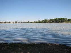
A peculiar tourist attraction, a product of man's whimsy is the artificial “Nainari Lagoon” with a 2 kilometres (1.2 miles) perimeter located at the western city limits between Guerrero and Padre Eusebio Kino avenues. It is the ideal place for outdoor sports, and its two piers are perfect for all type of aquatic activities like skiing, sailing and canoeing being the site for triathlons, marathons, bicycle races and all kind of sports competitions. For everyone's delight, cold coconut stands where you can find the freshest coconuts and other fuits such as mango con chile, and restaurants. It is also a romantic place for couples to be at night, or just when the sun is going down. Some of the people just go to the lagoon to spend time with their friends/family.
This small oasis is artificial, built in 1956, one of the great achievements of City Mayor Rene Gandara, who opened the hydraulic gates to fill the reservoir. Before, it was a lagoon region where there was duck hunting and rice was grown.
The Nainari Lagoon is the city's oxygen lung and tourist attraction that provides the city with a beautiful panorama, it has small boardwalk and a boat dock. It also has a shelter for young tourists by the water's edge. Water is constantly circulating as it is connected with one of the main canals in the irrigation district, the Lower Canal.
The Lagoon has been in recent years better tended and remodeled by the authorities. It has at its entrance a small garden with a bronze statue of a discus thrower which gives it much enhancement. Just next to the lagoon there is a sports complex "deportivo". It has an Olympic size swimming pool and it has all types of sport courts such as tennis, basketball, soccer, fronton, etc.
Ostimuri Children's Park
Next to the Nainari Lagoon we have the Ostimuru Children's Park and the Ostimuri Zoo, the best place to stroll with the family, here you will find an ample variety of mechanical rides for your children. The trees that surround this place cover it with lush branches like a caress from the sky. At the park's edge is the Ostimuri Zoo - an artificial habitat where a wide variety of animals exist, the song of birds as you stroll through this place is like a melody from heaven. As you make your journey in the midst of animals, you are surpassed by a boa as if it were a guardian of this place.
Yaqui Museum
The museum offers a perspective of Yaqui culture having among its objectives rescuing, preserving, investigating and spreading the culture and way of life of the Yaquis. As well as stimulating in the state's population the rediscovery of historical, linguistic and ethnic values of the Yaquis. Another objective is to show Sonoran children and teens the particular characteristics of Yaqui personality and the richness of their folklore. Another objective is to raise consciousness among Sonorans in regards to the development of historical events of the Yaquis as well as the important influence that they had in the formation of groups and classes that constitute the regions current society. This is made more accessible through visuals and scenes of daily life of the population of said tribe, mounted with the instruments, tools and original clothing that has been with them since ancient times and distinguish them on and international level.
Cocorit House
This construction dates from the previous century, its architecture is of colonial style. It has four exhibition rooms and an ample garden where we find permanent samples of painting and sculptures as well as arts and crafts. Among the House's visitors is the internationally renowned sculpture and painter Jose Luis Cuevas. Among the objectives of Cocorit House is to support art in those people with artistic attributes that don't have enough support. That is why local artists call it the region's haven for the arts.
"Álvaro Obregón" Dam
The General Álvaro Obregón Dam also called the Oviachic Dam, named taken from the place where it is located, starts its construction in the year 1947 and it's finished in 1952, being filled for the first time on July the same year. It is located 35 kilometres (22 miles) north of Ciudad Obregón.
Lake Oviachic has a surface of 20,500 acres (83 square kilometres) and a storage capacity of 3226 millions of cubic meters; it is part of the dam system on the Yaqui River, it's the state's largest dam and the third located on said river. From the Oviachic Dam a 27,603-kilometre (17,152-mile) network of main and secondary canals is derived that irrigate 450,000 hectares (1,100,000 acres) of surface in the Yaqui and Mayo Valleys, being one of the most important hydraulic infrastructures in the country. During the last two decades this hydraulic work has become one of the main and most visited tourist destinations in our region.
Huivulai Island
Huivulai Island is located 50 kilometres (31 miles) south of Ciudad Obregón and 5 miles (8.0 kilometres) off the Sonora coast in the Gulf of California (Sea of Cortez). In Mayo, Huivulai means "long neck". The island is 17 kilometres (10.6 miles) long and 1.2 kilometres (0.7 miles) wide at its widest part. The island features many natural attractions including sand dunes used by four-wheel drive vehicles. The island has a water well oasis surrounded by date trees that attract many species of birds, including gray and white pelicans, corvetta, gray crested cranes, storks, and albatrosses. The island is ringed by beaches and features fishing opportunities off-shore.
Sports
The most popular sport in Obregon is baseball. The city's professional baseball team is the Yaquis of the Mexican Pacific League, who play at Tomás Oroz Gaytán Stadium.
Obregón F.C. play professional soccer in the Segunda División.
Notable People
- Giovanny Gallegos - Major League Baseball pitcher
- Hector Velázquez - Major League Baseball pitcher[10]
International relations
Twin towns — Sister cities
Ciudad Obregón is twinned with:
Notes
- ↑ Station ID for Ciudad Obregon is 76258 Use this station ID to locate the sunshine duration
References
- ↑ "Normales Climatológicas Ciudad Obregón 1961-2014". Retrieved 9 April 2017.
- ↑ "Normales Climatológicas Ciudad Obregón 2015-2017". Retrieved 9 April 2017.
- ↑ "Normal Temperatures and Precipitation for Ciudad Obregón 1981-2010" (in Spanish). Servicio Meteorológico Nacional. Retrieved 9 April 2017.
- ↑ "Extreme Temperatures and Precipitation for Ciudad Obregón 1961-2010" (in Spanish). Servicio Meteorológico Nacional. Retrieved June 1, 2017.
- ↑ "Station 76258 Ciudad Obregon". Global station data 1961–1990—Sunshine Duration. Deutscher Wetterdienst. Retrieved 9 February 2016.
- ↑ Columbia-Lippincott Gazetteer. (New York: Columbia University Press, 1952) p. 406
- ↑ "Census Data". Retrieved 7 February 2013.
- ↑ "Archived copy". Archived from the original on 2013-10-04. Retrieved 2013-02-07.
- ↑ Oficina Nacional de Desarrollo Humano (2005). "IDH Municipal 2000-2005 base de datos". Archived from the original on 2009-03-06. Retrieved 2008-12-17.
- ↑ "Hector Velázquez Stats, Fantasy & News". Boston Red Sox.
- ↑ "Sister City Fun: Dinner Honors Visitors Here on Mexican Exchange". Baton Rouge Morning Advocate (sec. B, p. 2). June 29, 1977.
- ↑ "About Us..." tucsonmexicosistercities.org. 2017. Retrieved 2018-05-03.
| Wikivoyage has a travel guide for Ciudad Obregón. |
Coordinates: 27°29′38″N 109°56′20″W / 27.49389°N 109.93889°W