City walls of Nuremberg
Walls of Nürnberg | |
|---|---|
| Stadtmauer Nürnberg | |
| Part of Nürnberg (Nuremberg) | |
| Nuremberg, Germany | |
 | |
 Walls of Nürnberg | |
| Coordinates | 49°27′27.72″N 11°5′17.88″E / 49.4577000°N 11.0883000°ECoordinates: 49°27′27.72″N 11°5′17.88″E / 49.4577000°N 11.0883000°E |
| Type | City walls |
| Site information | |
| Owner | Nuremberg |
| Condition | Intact |
| Site history | |
| Built | 11th Century - 16th Century |
| In use | 11th Century - 1940's |
| Battles/wars | Battle of Nuremberg (1945) |
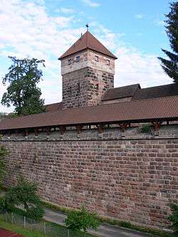
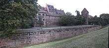
The city walls of old city Nürnberg, in modern-day Nuremberg, are the defensive mechanism surrounding the city of Nuremberg, Germany. Construction started in the 12th Century and ended officially in the 16th Century, and they run for 5 kilometers (about 4 kilometers still standing) around the old town. The Nuremberg Castle together with the city wall is meant to be one of Europes most considerable medieval defensive systems.[1]
Notes and references
Sources and external links
| Wikimedia Commons has media related to City walls of Nuremberg. |
- commons:Stadtmauer Nürnberg Coding and pictures of wall towers and gates.
- baukunst-nuernberg Map and photographs (German only)
Rotes K
This article is issued from
Wikipedia.
The text is licensed under Creative Commons - Attribution - Sharealike.
Additional terms may apply for the media files.