Cima di Rosso
| Cima di Rosso | |
|---|---|
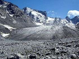 The Cima di Rosso (centre-left) from the Forno Glacier (north side) | |
| Highest point | |
| Elevation | 3,366 m (11,043 ft) |
| Prominence | 266 m (873 ft) [1] |
| Parent peak | Cima di Castello |
| Coordinates | 46°18′23″N 9°43′6″E / 46.30639°N 9.71833°ECoordinates: 46°18′23″N 9°43′6″E / 46.30639°N 9.71833°E |
| Geography | |
 Cima di Rosso Location in the Alps | |
| Location |
Graubünden, Switzerland Lombardy, Italy |
| Parent range | Bregaglia Range |
The Cima di Rosso is a mountain in the Bregaglia Range of the Alps, located on the border between Italy and Switzerland. It lies between the valleys of Bregaglia (in Graubünden) and Malenco (in Lombardy). On the western side of the mountain is the Forno Glacier.
References
- ↑ Retrieved from the Swisstopo topographic maps and Google Earth. The key col is located west of the Torrone Orientale at 3,100 metres.
External links
This article is issued from
Wikipedia.
The text is licensed under Creative Commons - Attribution - Sharealike.
Additional terms may apply for the media files.