Chyle Hole
| Chyle Hole | |
|---|---|
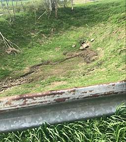 The Chyle in May 2018 | |
| Location | NE of Warren, New York |
| Coordinates | 42°52′55″N 74°52′56″W / 42.88208°N 74.88213°WCoordinates: 42°52′55″N 74°52′56″W / 42.88208°N 74.88213°W |
| Elevation | 1,570 feet (479 m) |
| Width | 75 feet (23 m) |
| Depth | 12 feet (3.7 m) |
Chyle Hole or Kyle[1] is a depression or hole where a stream disappears. It is located in the Town of Springfield north of Chyle Road by the Warren town line. It was known to the Indians as Theogsowone which translates to "wedge".[2][1]
The bottoms and sides of Chyle Hole are limestone, partially covered with earth. There are 2 or 3 cracks in the bottom that the water flows into during heavy rain or snow melt. Sometimes it fills and covers an area up to 3 acres with a lake that eventually drains into the hole.[3]
References
- 1 2 Bailey, William Theodore (1874). Richfield Springs and Vicinity. A.S. Barnes & Company. p. 155. Retrieved 30 November 2017.
- ↑ "The young family". threerivershms.com. threerivershms.com. 1990. Retrieved 29 November 2017.
- ↑ Macauley, James (1829). The natural, statistical, and civil history of the state of New-York, Volume 1. NYS. p. 271. Retrieved 29 November 2017.
This article is issued from
Wikipedia.
The text is licensed under Creative Commons - Attribution - Sharealike.
Additional terms may apply for the media files.