Church Rock (Navajo County, Arizona)
| Church Rock | |
|---|---|
 | |
| Highest point | |
| Elevation | 5,862 ft (1,787 m) NGVD 29[1] |
| Prominence | 472 ft (144 m) [1] |
| Coordinates | 36°44′04″N 110°07′07″W / 36.7344445°N 110.1187371°WCoordinates: 36°44′04″N 110°07′07″W / 36.7344445°N 110.1187371°W [2] |
| Geography | |
 Church Rock | |
| Location | Navajo County, Arizona, U.S. |
| Topo map | USGS Church Rock |
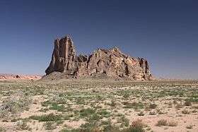
Church Rock is a pillar in Navajo County, Arizona. It is located near the mouth of Church Rock Valley with a summit elevation of 5,862 feet (1,787 m).[1]
History
Church Rock was originally named Artenesales de Piedra or Sculpted Rock, by the Mexican merchant and explorer Antonio Armijo in 1829-1830, when the area was explored by his expedition to find a trade route between Santa Fe de Nuevo México and Alta California. This would become the Armijo Route of the Old Spanish Trail.[3][4]
References
- 1 2 3 "Church Rock AZ". ListsOfJohn.com. Retrieved 2016-08-24.
- ↑ "Church Rock". Geographic Names Information System. United States Geological Survey. Retrieved 2016-08-24.
- ↑ Diario que formo yo el ciudando Antonio Armijo, como comandante, para el descubrimiento del camino para el punto de las Californias (Diary made by citizen Antonio Armijo as commandant for the discovery of the route to the Californias), Official Register of the Government the United States of Mexico, 1830, pp. 205-206
- ↑ LeRoy R. Hafen and Antonio Armijo, Armijo's Journal,Huntington Library Quarterly, Vol. 11, No. 1 (Nov., 1947), pp. 87-101, Published by: University of California Press, DOI:10.2307/3816035
This article is issued from
Wikipedia.
The text is licensed under Creative Commons - Attribution - Sharealike.
Additional terms may apply for the media files.