Chowilla, South Australia
| Chowilla South Australia | |||||||||||||||
|---|---|---|---|---|---|---|---|---|---|---|---|---|---|---|---|
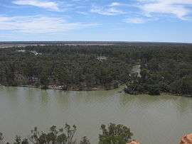 Chowilla as viewed from Headings Cliff on the opposite side of the Murray River. | |||||||||||||||
 Chowilla | |||||||||||||||
| Coordinates | 33°44′49″S 140°52′22″E / 33.74689179°S 140.87289131°ECoordinates: 33°44′49″S 140°52′22″E / 33.74689179°S 140.87289131°E | ||||||||||||||
| Established | 26 April 2013[1] | ||||||||||||||
| Postcode(s) | 5341[2] | ||||||||||||||
| Time zone | ACST (UTC+9:30) | ||||||||||||||
| • Summer (DST) | ACST (UTC+10:30) | ||||||||||||||
| Location | |||||||||||||||
| LGA(s) | Pastoral Unincorporated Area[3] | ||||||||||||||
| County | Hamley[1] | ||||||||||||||
| State electorate(s) | Chaffey[4] | ||||||||||||||
| Federal Division(s) | Barker[5] | ||||||||||||||
| |||||||||||||||
| Footnotes |
Coordinates[1] Adjoining localities[6] | ||||||||||||||
Chowilla is a locality in the Australian state of South Australia located on the northern side of the Murray River about 250 kilometres (160 miles) to the north-east of the capital city of Adelaide and about 40 kilometres (25 miles) to the north-east of the town of Renmark, and which is bounded by the border with New South Wales in the east.[6][7]
The locality was established on 26 April 2013 in respect to “the long established local name.”[1]
The land use within Chowilla is concerned with the following protected areas, the Chowilla Game Reserve and the Chowilla Regional Reserve which have fully occupied its extent since its establishment in 2013.[6][7]
There are three historic sites within Chowilla which have been listed on the South Australian Heritage Register: the Suicide Bridge (or Lunatic Bridge), including nearby remnant posts from the New South Wales-South Australia telegraph line and Littra House, both near Lake Littra, and Todd's Obelisk, near the New South Wales border.[8][9][10]
Chowilla is located within the federal Division of Barker, the state electoral district of Chaffey, the Pastoral Unincorporated Area of South Australia and the state’s Murray and Mallee region.[3][4][5][11]
See also
References
- 1 2 3 4 "Search result for "Chowilla (LOCB)" (Record no SA0067035) with the following layers selected - "Suburbs and Localities", "County" and "Place names (gazetteer)"". Property Location Browser. Department of Planning, Transport and Infrastructure. Archived from the original on 12 October 2016. Retrieved 15 August 2015.
- ↑ "Search result for Chowilla, SA". Australia Post. Retrieved 29 September 2015.
- 1 2 "Development Plan, Land Not Within a Council Area Eyre, Far North, Riverland and Whyalla – 18 October 2012" (PDF). Department of Planning, Transport and Infrastructure. 2012. pp. 20, 23 & 289. Archived from the original (PDF) on 23 September 2015. Retrieved 16 September 2015.
- 1 2 "District of Chaffey Background Profile". Electoral Commission SA. Retrieved 26 September 2015.
- 1 2 "Federal electoral division of Grey, boundary gazetted 16 December 2011" (PDF). Australian Electoral Commission. Retrieved 1 October 2015.
- 1 2 3 Proposed Locality Boundaries for Pastoral Areas (PDF) (Map). Department for Planning, Transport and Infrastructure, Government of South Australia. 31 October 2012. Rack Plan 951. Retrieved 5 September 2015.
- 1 2 "A Review of Chowilla Regional Reserve 1993 - 2003" (PDF). Department for Environment and Heritage. 2003. pp. 4 & 5. Retrieved 29 September 2015.
- ↑ "Suicide Bridge (previously Lunatic Bridge) [Timber Trestle] & former NSW-SA Telegraph Line Posts, Chowilla Game Reserve [Part of Bookmark Biosphere Reserve Buffer Zone]". South Australian Heritage Register. Department of Environment, Water and Natural Resources. Archived from the original on 16 February 2016. Retrieved 12 February 2016.
- ↑ "Littra House (former Scab or Sheep Inspector's House; possibly former Customs House) and Graveyard, Chowilla Game Reserve [Part of Bookmark Biosphere Reserve Buffer Zone]". South Australian Heritage Register. Department of Environment, Water and Natural Resources. Retrieved 12 April 2016.
- ↑ "Border Cairn (Todd's Obelisk), Chowilla Game Reserve [Part of Bookmark Biosphere Reserve Buffer Zone], Lake Littra]". South Australian Heritage Register. Department of Environment, Water and Natural Resources. Archived from the original on 16 February 2016. Retrieved 12 February 2016.
- ↑ "Murray and Mallee SA Government region" (PDF). The Government of South Australia. Retrieved 10 October 2014.