Chott Ech Chergui
| Chott Ech Chergui شط الشرقي | |
|---|---|
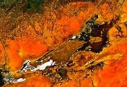 from space | |
 Chott Ech Chergui Chott ach-Chargui in Algeria | |
| Coordinates | 34°21′N 0°30′E / 34.35°N 0.5°ECoordinates: 34°21′N 0°30′E / 34.35°N 0.5°E |
| Type | Endorheic salt lake |
| Basin countries | Algeria |
| Max. length | 160 km (99 mi) |
| Max. width | 24 km (15 mi) |
| Surface area | 2,000 km2 (770 sq mi) |
| Surface elevation | 1,027 m (3,369 ft) above sea level |
| Designated | 2 February 2001 |
| Reference no. | 1052[1] |
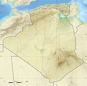
Chott Ech Chergui (Arabic: شط الشرقي) is a large endorheic salt lake in Saïda Province, northwestern Algeria.[2] It is located at 34°21′N 0°30′E / 34.35°N 0.5°E in the level terrain of the Hautes Plaines region between the Tell Atlas and the Saharan Atlas and is one of the largest lakes in Algeria.
Ecology
The Chott Ech Chergui has an area of about 2000 km² where water collects during the wet season, forming a number of large shallow salt lakes which become salt flats as they dry. The lake area has a length of about 160 km from ENE to WSW and lies at an average elevation of 1000 m.[3]
Chott Ech Chergui has been designated a Ramsar wetland of international importance. The Ramsar site has an area of 8555 km² and is the natural environment for a number of threatened and vulnerable animal and plant species.[4]
See also
References
- ↑ "Chott Ech Chergui". Ramsar Sites Information Service. Retrieved 25 April 2018.
- ↑ Chott ech Chergui - Wilaya de Saida
- ↑ Magdi Masgidi & Shafi Noor Islam, Wetlands Management in Algeria: A Case Study on Chott Ech Chergui.
- ↑ Wetlands of International Importance: Algeria, Chott Ech Chergui
External links
- (in English) Ramsar Convention website
- (in French) Direction Générale des Forêts