Chotila
| Chotila ચોટીલા | |
|---|---|
| Town | |
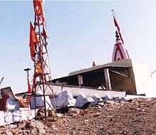
.jpg) Chamunda Devi Temple, Chotila | |
 Chotila Location in Gujarat, India  Chotila Chotila (India) | |
| Coordinates: 22°25′30″N 71°11′17″E / 22.425°N 71.188°ECoordinates: 22°25′30″N 71°11′17″E / 22.425°N 71.188°E | |
| Country |
|
| State | Gujarat |
| District | Surendranagar |
| Languages | |
| • Official | Gujarati, Hindi |
| Time zone | UTC+5:30 (IST) |
| Vehicle registration | GJ-13 |
| Website |
www |
Chotila is a Hindu temple town and Taluka headquarters of Chotila Taluka, Surendranagar district, located near Rajkot, Gujarat, India.
History
Chotila was called Chotgadh in ancient times. It was originally a holding of the Sodha Parmars but was conquered from Jagsio Parmar by the Khachar Kathis who made it one of their principal seats. Most of the Khachar Kathis trace their origin to the Chotila house. Chotila was acquired by the Kathis in 1566 AD. It is the head quarters of an Agency thana during British period.[1]
Demographics
The population according to the census of 1872 was 1771 and according to that of 1881 2029 souls.[1] It has population of nearly 20000.
Places of interest
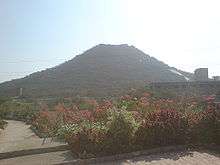
The Chamund or Chotila hill which is surmounted by the temple of Chamunda and is 1173 feet in height. The temple is reached by climbing 620 steps.[1][2] The temple is open for devotees from 5 am to 7.30 pm.
Administration
The town is administered by the Nagarpalika.
See also
References
- 1 2 3 Gazetteer of the Bombay Presidency: Kathiawar (Public Domain text). VIII. Printed at the Government Central Press, Bombay. 1884. p. 407.
- ↑ touristlink.com
| Wikimedia Commons has media related to Chotila. |
![]()