Chom Bueng District
| Chom Bueng จอมบึง | |
|---|---|
| Amphoe | |
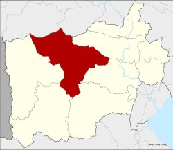 Amphoe location in Ratchaburi Province | |
| Coordinates: 13°37′11″N 99°35′30″E / 13.61972°N 99.59167°ECoordinates: 13°37′11″N 99°35′30″E / 13.61972°N 99.59167°E | |
| Country | Thailand |
| Province | Ratchaburi |
| Tambon | 6 |
| Muban | 90 |
| Area | |
| • Total | 772.1 km2 (298.1 sq mi) |
| Population (2017) | |
| • Total | 63,702 |
| • Density | 82.50/km2 (213.7/sq mi) |
| Time zone | UTC+7 (ICT) |
| Postal code | 70150 |
| Geocode | 7002 |
Chom Bueng (Thai: จอมบึง, pronounced [t͡ɕɔ̄ːm bɯ̄ŋ]) is a district (amphoe) of Ratchaburi Province in western Thailand.
Geography
Neighboring districts are (from the north clockwise) Dan Makham Tia and Tha Muang of Kanchanaburi Province, and Photharam, Mueang Ratchaburi, Pak Tho, Ban Kha and Suan Phueng.
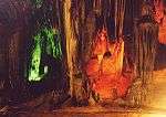
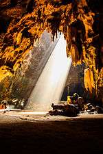
Several caves are found in the district. Khao Bin cave is regarded as the most beautiful, having many stalactites and stalagmites and a "holy" pond. The cave is named after a rock formation which looks like a flying bird. Chomphon cave was renamed by King Chulalongkorn during his visit in the area in 1895, due to a stalactite that resembled an epaulette of a field marshal.
History
In 1895 King Chulalongkorn and Queen Saovabha visited Ratchaburi Province, including the district. The king saw a large lake there. He then renamed the area big lake or chom bueng, and made it a minor district (king amphoe).
In 1958 Chom Bueng was upgraded to Amphoe Chom Bueng.[1]
Administration
Central administration
The district Chom Bueng is divided into six sub-districts (tambon), which are further subdivided into 90 administrative villages (Muban).
| No. | Name | Thai | Villages | Pop.[2] |
|---|---|---|---|---|
| 1. | Chom Bueng | จอมบึง | 13 | 15,441 |
| 2. | Pak Chong | ปากช่อง | 16 | 9,706 |
| 3. | Boek Phrai | เบิกไพร | 11 | 6,062 |
| 4. | Dan Thap Tako | ด่านทับตะโก | 20 | 13,540 |
| 5. | Kaem On | แก้มอ้น | 15 | 9,720 |
| 6. | Rang Bua | รางบัว | 15 | 9,233 |
Local administration
There are two sub-district municipalities (Thesaban Tambon) in the district:
- Chom Bueng (Thai: เทศบาลตำบลจอมบึง) consisting of parts of the sub-district Chom Bueng.
- Dan Thap Tako (Thai: เทศบาลตำบลด่านทับตะโก) consisting of parts of the sub-district Dan Thap Tako.
There are six sub-district administrative organizations (SAO) in the district:
- Chom Bueng (Thai: องค์การบริหารส่วนตำบลจอมบึง) consisting of parts of the sub-district Chom Bueng.
- Pak Chong (Thai: องค์การบริหารส่วนตำบลปากช่อง) consisting of the sub-district Pak Chong.
- Boek Phrai (Thai: องค์การบริหารส่วนตำบลเบิกไพร) consisting of the sub-district Boek Phrai.
- Dan Thap Tako (Thai: องค์การบริหารส่วนตำบลด่านทับตะโก) consisting of parts of the sub-district Dan Thap Tako.
- Kaem On (Thai: องค์การบริหารส่วนตำบลแก้มอ้น) consisting of the sub-district Kaem On.
- Rang Bua (Thai: องค์การบริหารส่วนตำบลรางบัว) consisting of the sub-district Rang Bua.
References
- ↑ "พระราชกฤษฎีกาจัดตั้งอำเภอกระสัง อำเภอกระนวน อำเภอบางกอกใหญ่ อำเภอขุนหาร อำเภอพนา อำเภอปากช่อง อำเภอวังเหนือ อำเภอวังชิ้น อำเภอแม่ทา อำเภอหนองหมู อำเภอสระแก้ว อำเภออมก๋อย อำเภอบางซ้าย อำเภอทับสะแก อำเภอบุณฑริก อำเภอลานสะกา อำเภอจอมบึง อำเภอท่ายาง อำเภอสามเงา อำเภอฟากท่า อำเภอบ้านเขว้า อำเภอชานุมาน อำเภอแม่พริก อำเภอท่าสองยาง อำเภอสะเมิง อำเภอหนองแขม อำเภอพระแสง พ.ศ. ๒๕๐๑" (PDF). Royal Gazette (in Thai). 75 (55 ก): 321–327. 1958-07-22.
- ↑ "Population statistics 2017" (in Thai). Department of Provincial Administration. Retrieved 2018-04-05.