Cholame Hills
| Cholame Hills | |
|---|---|
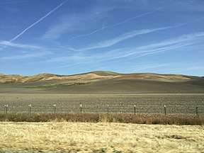 View of the Cholame Hills from CA 46. | |
| Highest point | |
| Elevation | 675 m (2,215 ft) |
| Geography | |
 Location of the Cholame Hills in California [1] | |
| Country | United States |
| State | California |
| District | Monterey County |
| Range coordinates | 35°49′13.877″N 120°25′35.558″W / 35.82052139°N 120.42654389°WCoordinates: 35°49′13.877″N 120°25′35.558″W / 35.82052139°N 120.42654389°W |
| Parent range |
Temblor Range, California Coast Ranges |
| Topo map | USGS Cholame Hills |
The Cholame Hills are a low mountain range, located in extreme southeastern Monterey County, California.[1]
They are a northern extension of the Temblor Range, both of the California Coast Ranges System.
To the south of the range lies CA Route 46, and the town of Cholame, California.
See also
- California Flats Solar Project — proposed for the area.
References
- 1 2 "Cholame Hills". Geographic Names Information System. United States Geological Survey. Retrieved 2009-05-04.
This article is issued from
Wikipedia.
The text is licensed under Creative Commons - Attribution - Sharealike.
Additional terms may apply for the media files.