Chojata District
| Chojata | |
|---|---|
| District | |
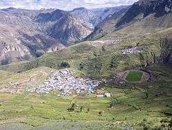 A view of Chojata and the mountains north and north-west of it | |
| Country |
|
| Region | Moquegua |
| Province | General Sánchez Cerro |
| Founded | February 15, 1955 |
| Capital | Chojata |
| Government | |
| • Mayor | Lucio Maldonado Roque |
| Area | |
| • Total | 847.94 km2 (327.39 sq mi) |
| Elevation | 3,625 m (11,893 ft) |
| Population (2005 census) | |
| • Total | 1,986 |
| • Density | 2.3/km2 (6.1/sq mi) |
| Time zone | UTC-5 (PET) |
| UBIGEO | 180202 |
Chojata District is one of eleven districts of the General Sánchez Cerro Province in Peru.[1]
Geography
One of the highest peaks of the district is Hatun P'ukru at approximately 5,153 m (16,906 ft). Other mountains are listed below:[2]
- Chachakumani
- Chinchillani
- Ch'alla Pata
- Hatun Pampa
- Hatun Punta
- Iru Urqu
- Kimsa Chata
- Kunturini
- Laq'a Laq'ani
- Llallawi
- Millu Punta
- Misiwa
- Paqu Paquni
- Pata Wasi
- Patilla Suru
- Pirwa Tira
- Puka Apachita
- Pukara
- Putusi
- Phaq'u Q'awa
- P'aqu Urqu
- P'isaqani
- Qarwayuni
- Qullqi Wiqu
- Quncha Pata
- Q'asa Q'asa
- Q'uwata
- Sikuwani
- Surani
- Uqi Salla
- Wari Pukara
- Wila Wila
- Wila Wilani
- Yana Qaqa
- Yawri Salla
- Yuraq Qaqa
- Yuraq Urqu
Ethnic groups
The people in the district are mainly indigenous citizens of Quechua descent. Quechua is the language which the majority of the population (85.33%) learnt to speak in childhood, 10.40% of the residents started speaking using the Spanish language (2007 Peru Census).[3]
References
- ↑ (in Spanish) Instituto Nacional de Estadística e Informática. Banco de Información Distrital Archived April 23, 2008, at the Wayback Machine.. Retrieved April 11, 2008.
- ↑ escale.minedu.gob.pe/ UGEL map General Sánchez Cerro Province (Moquegua Region)
- ↑ inei.gob.pe Archived January 27, 2013, at the Wayback Machine. INEI, Peru, Censos Nacionales 2007, Frequencias: Preguntas de Población: Idioma o lengua con el que aprendió hablar (in Spanish)
| |
|---|---|
| General Sánchez Cerro | |
| Ilo | |
| Mariscal Nieto | |
This article is issued from
Wikipedia.
The text is licensed under Creative Commons - Attribution - Sharealike.
Additional terms may apply for the media files.