Chinautla
| Chinautla | |
|---|---|
 | |
 Chinautla Location in Guatemala | |
| Coordinates: 14°42′0″N 90°30′0″W / 14.70000°N 90.50000°WCoordinates: 14°42′0″N 90°30′0″W / 14.70000°N 90.50000°W | |
| Country |
|
| Department | Guatemala |
| Government | |
| • Mayor (2016-2020) | Brenda del Cid Medrano[3] (LIDER) |
| Area | |
| • Total | 30 sq mi (80 km2) |
| Elevation | 4,042 ft (1,232 m) |
| Population (2002) | |
| • Total | 77,071 |
| Climate | Aw |
Chinautla (Spanish pronunciation: [tʃiˈnautla]) is a municipality in the Guatemala department of Guatemala. According to the 2002 census, it had a population of 77,071,[4] making it the ninth-largest city in the country and the seventh largest in the Guatemala Department.
Administrative division
Chinautla has eleven villages:[5]
- Los Jocotales
- San Martín
- San José Buena Vista
- El Durazno
- Tres Sabanas
- Las Lomas
- Cumbre de Guayabo
- San Antonio las Flores
- San Rafael las Flores
- La Laguneta
- El Chan
- Concepción Sacojito[6]
Climate
Chinautla has tropical climate (Köppen: Aw).
| Climate data for Chinautla | |||||||||||||
|---|---|---|---|---|---|---|---|---|---|---|---|---|---|
| Month | Jan | Feb | Mar | Apr | May | Jun | Jul | Aug | Sep | Oct | Nov | Dec | Year |
| Average high °C (°F) | 25.8 (78.4) |
26.8 (80.2) |
28.3 (82.9) |
28.7 (83.7) |
28.4 (83.1) |
27.0 (80.6) |
26.8 (80.2) |
27.1 (80.8) |
26.4 (79.5) |
26.0 (78.8) |
25.8 (78.4) |
25.5 (77.9) |
26.9 (80.4) |
| Daily mean °C (°F) | 19.6 (67.3) |
20.3 (68.5) |
21.6 (70.9) |
22.5 (72.5) |
22.7 (72.9) |
22.2 (72) |
21.9 (71.4) |
22.0 (71.6) |
21.6 (70.9) |
21.1 (70) |
20.4 (68.7) |
19.6 (67.3) |
21.3 (70.3) |
| Average low °C (°F) | 13.5 (56.3) |
13.9 (57) |
15.0 (59) |
16.3 (61.3) |
17.0 (62.6) |
17.4 (63.3) |
17.1 (62.8) |
16.9 (62.4) |
16.8 (62.2) |
16.2 (61.2) |
15.0 (59) |
13.7 (56.7) |
15.7 (60.3) |
| Average precipitation mm (inches) | 1 (0.04) |
2 (0.08) |
5 (0.2) |
25 (0.98) |
103 (4.06) |
207 (8.15) |
187 (7.36) |
132 (5.2) |
211 (8.31) |
96 (3.78) |
16 (0.63) |
2 (0.08) |
987 (38.87) |
| Source: Climate-Data.org[7] | |||||||||||||
Geographic location
Located at the center of Guatemala Department, it is surrounded by municipalities of that Department only:[5]
Places adjacent to Chinautla | |
|---|---|
See also

- List of places in Guatemala
- Guatemala City
Notes and references
References
- ↑ Valdeavellano, Alberto G. (1897). "Indígenas de Chinautla". La Ilustración Guatemalteca (in Spanish). Guatemala. I (15). Retrieved 19 October 2015.
- ↑ Valdeavellano, Alberto G. (1897). "Indígenas de Chinautla". La Ilustración Guatemalteca (in Spanish). Guatemala. I (15). Retrieved 19 October 2015.
- ↑ "Alcaldes de la zona metropolitana empiezan a definirse". Prensa Libre (in Spanish). Guatemala. 8 September 2015. Retrieved 8 September 2015.
- ↑ http://www.citypopulation.de/Guatemala.html
- 1 2 3 4 "Municipios del departamento de Guatemala". SEGEPLAN (in Spanish). Guatemala. Archived from the original on 7 July 2015. Retrieved 22 July 2015.
- ↑ "Monografía de Chinautla" (PDF). Municipalidad de Chinautla (in Spanish). Chinautla, Guatemala. 2009. Archived from the original (PDF) on July 10, 2009. Retrieved 19 October 2015.
- ↑ "Climate: Chinautla". Climate-Data.org. Retrieved 19 October 2015.
Bibliography
- Valdeavellano, Alberto G. (1897). "Indígenas de Chinautla". La Ilustración Guatemalteca (in Spanish). Guatemala. I (15). Retrieved 27 April 2015.
Further reading
Medrano Family (in Spanish)
- "Caen los Medrano por lavado de Q9 millones". Siglo 21 (in Spanish). Guatemala. 4 June 2013. Archived from the original on October 20, 2015.
- "Capturan a Medrano por lavado de dinero". Siglo 21 (in Spanish). Guatemala. 20 October 2015. Archived from the original on October 20, 2015.
- "MP: Medrano lavó Q9.9 millones con colaboración de ONG y constructora". ElPeriódico (in Spanish). Guatemala. 20 October 2015. Archived from the original on October 20, 2015.
External links

Capital: Guatemala City | ||
| Municipalities | 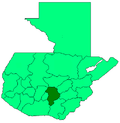 | |
| Authority control |
|---|
This article is issued from
Wikipedia.
The text is licensed under Creative Commons - Attribution - Sharealike.
Additional terms may apply for the media files.