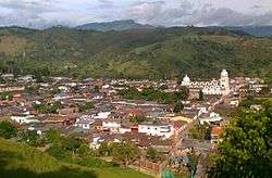
Chinácota
- Not to be confused with Chinauta
| Chinácota | |
|---|---|
| Municipality | |
 | |
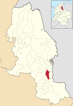 Location of the municipality and town of Chinácota in the Norte de Santander Department of Colombia. | |
| Country |
|
| Department | Norte de Santander Department |
| Area | |
| • Land | 166.64 km2 (64.34 sq mi) |
| Elevation | 1,175 m (3,855 ft) |
| Population (2015) | |
| • Municipality | 16,348 |
| • Urban | 11,086 |
| Time zone | UTC-5 (Colombia Standard Time) |
Chinácota is a small town and municipality located in the Department of Norte de Santander in Colombia, South America. This department is located on the North-Eastern region of the country, near the border with Venezuela. Chinácota has a population of approximately 15,000 people (town plus surroundings) according to the 2005 Colombian census.
The Municipality of Chinácota extends over 167 square kilometers and is located at an approximate altitude of 1,175 meters over the sea level. The average temperature range is between 12 and 22 degrees Celsius.
The urban area of Chinácota comprises about 29 neighborhoods and it includes a residential count of approximately 2,600 houses. Chinácota is expected to grow by about 66% by the year 2011.
History
Chinacota was founded in 1523 by the conquistador Don Pedro de Orsua and Don Ortun Velasco. when the conquistador Don Pedro de Ursula and her partner Don Ortun Velazco were entrusted to reduce Indians Bocarema, Chinaquillo, Bochaga and Bateca who in turn founded some populations, among them that of St. John the Baptist in today site called " Pueblo - straw " belonging to the nation of the chitareros, the name given by the Spaniards to the natives of the valleys of Bochalema, Chinácota and the Holy Spirit because" their entertainment and other revelries of the executed with chicaras totumo ( chítaro in single speech) reeds and other primitive tools .[1]
Geography:
Physical description:
The municipal territory is located in the valley that forms at the fork just before Pamplona, the Eastern Cordillera, at 7º37 'North Latitude and 72º36' West Longitude, from the Greenwich Meridian. The Municipality of Chinácota belongs to the Southeast subregion of the Norte de Santander Department
Act of demarcation between the municipalities of Chinácota and Ragonvalia (August 14, 1969, IGAC) "Starting from the geodesic point called" VIEJA 497 "located in the hill La Vieja and chosen as a place of competition for the territories of Chinácota, Villa del Rosario and Ragonvalia , it is continued by the high part of the mentioned hill until its completion in the Honda ravine; it is passed to the El Caliche ditch and through it until its birth in the El Fraile blade; the whole blade is followed to its highest part, El Fraile hill, point from which the blade is known as El Tábano. It continues towards the southwest, by the El Tábano blade to the nearest hill to the depression where it crosses the path of Palmarito, also characterized by a huge stone with a needle point.
This hill that in common agreement was called hill "Ramón González Valencia" was chosen as a contest point for the territories of Chinácota, Ragonvalia and Herrán, being at the same time the end of the line described (flat coordinates of the hill: X = 1.327. 000; Y = 837,750) "(sic) Act of demarcation between the municipalities of Chinácota and Herrán (August 30, 1969 IGAC). "Starting from the hill" Ramón González Valencia "(approximate flat coordinates X = 1,350,000, Y = 837,750) named by the Commission of Demarcation and chosen as a contest point for the territories of Chinácota, Ragonvalia and Herrán, it is followed by the El Tábano blade to Mount El Tábano; continue in a southeasterly direction (SE) through the whole blade that separates the slopes of the Iscalá creek and the Honda creek, until finding the geodesic point called "MEJUÉ 920", located in the moor of Mejué and whose landmark was chosen as a point of contest for the territories of Chinácota, Herrán and Toledo, end of the boundary line described "(sic) Act of demarcation between the municipalities of Chinácota and Toledo (August 29, 1969 IGAC). <ref>http://chinacota-nortedesantander.gov.co/informacion_general.shtml
External links
- (in Spanish) Chinácota official website
- (in Spanish) UfpsChinácota official website
- (in Spanish) Social Network UfpsChinácota website
Coordinates: 7°37′N 72°36′W / 7.617°N 72.600°W