Chhend Colony
| Chhend Colony | |
|---|---|
| neighbourhood | |
 | |
| Nickname(s): Chhend | |
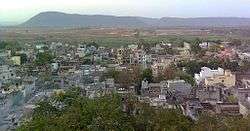
 Chhend Colony Location in Odisha, India | |
| Coordinates: 22°14′N 84°50′E / 22.24°N 84.83°ECoordinates: 22°14′N 84°50′E / 22.24°N 84.83°E | |
| Country |
|
| State | Odisha |
| District | Sundargarh |
| Area | |
| • Total | 24 km2 (9 sq mi) |
| Elevation | 219 m (719 ft) |
| Population (2010) | |
| • Total | 2,05,000 |
| • Density | 90/km2 (200/sq mi) |
| Languages | |
| • Official | Odia |
| Time zone | UTC+5:30 (IST) |
| PIN | 769015 |
| Telephone code | 91 661 |
| Vehicle registration | OD-14(OR-14 before 2012) |
.jpg)
Chhend Colony is a mixed income group commercial-cum-residential area in the West Rourkela, of Sundergarh district. It is one of the largest Colony in Asia. Chhend Colony of Rourkela is situated in Trans Urban area of Rourkela. It is most known for the Management college of Rourkela Institute of Management Studies & Biju Patnaik University of Technology, Rourkela.
Overview
Chhend Colony comprises Kalinga Vihar, Gopabandhu Nagar, and Madhusudan Nagar and is close to Rourkela Airstip and Rourkela Steel Plant. The area is famous for the private residential plot's and Management Institute of Rourkela Institute of Management Studies, Pharmacy College of Kanak Manjari Institute of Pharmaceutical Sciences and Universities of Biju Patnaik University of Technology. The area is one of the most populous colony of the Rourkela city with a population of around 3.5 lakhs.[1]
Residential colonies
- Kalinga Vihar
- Gopabandhu Nagar
- Madhusudan Nagar
- Tisco Colony
- Saraswati Colony
- Kalyani Naggar
- Phase II
- Co operative colony
- Kaushalya Vihar.
- Kishan tola.
Education
- Biju Patnaik University of Technology
- Raghavendra Distance Education (Direct 10th,+2Science,Commerce,Arts).B.A,BSC,B.COM,09438338385,09583220626
- Rourkela Institute of Management Studies
- Kanak Manjari Institute of Pharmaceutical Sciences
- Chinmaya Vidyalaya EM School
- Utkalmani Gopabandhu Institute of Engineering, Rourkela
- J.P Motion Pictures ,Rourkela
- Government ITI
- Hrushikesh Ray Mahavidyalya
- St.Thomas English School, Kalinga vihar
Nearest station
| Stations | Distance |
|---|---|
| Rourkela Railway Station | 5 km |
| Rourkela Bus Stand | 8 km |
Panposh railway Station
See also
- AAMA Rourkela
References
- ↑ Rourkela Tourism Guide Book
| Wikimedia Commons has media related to Chhend Colony. |