Cherry Street (Philadelphia)
.jpg) Pennsylvania Academy of the Fine Arts at the corner of 14th and Cherry Streets in 1900 | |
| Maintained by | City of Philadelphia |
|---|---|
| Postal code | 19102, 19103, 1904 |
| North | Race Street |
| South | Arch Street |
| Construction | |
| Commissioned | 1682 |
Cherry Street is a minor east-west street in Philadelphia, Pennsylvania that runs parallel to Race Street to the north and Arch Street to the south. It was not one of William Penn's original gridded streets from the 1680s, and began as an alleyway between numbered streets.[1] It is listed by name on the map in Birch's Views of Philadelphia (1800) – Race and Arch Streets are listed by their original names, "Sassafras" and "Mulberry." The earliest official use of the name Cherry Street was in 1809.[2]
Location
It is not continuous through the eastern half of Center City. On blocks it did not cut through, minor streets just north or south of it were assigned the name.[2] From Front to 2nd Streets it is called Elfreth's Alley, established in 1702, and purported to be the nation's oldest continuously-inhabited residential street.[3] From Bread to 3rd Streets it was called Fetter Street. From 3rd to 4th Streets it was called Hill Street.[4] From 4th to 7th Streets is it discontinuous because of the U.S. Mint, Independence Mall, and the Federal Reserve Bank of Philadelphia. From 7th to 11th Streets it passes through Philadelphia's Chinatown. From 11th to Broad (14th) Streets it is discontinuous because of the Pennsylvania Convention Center. A half-block of it, from Broad to Carlisle Streets, has been converted into a plaza and sculpture garden for the Pennsylvania Academy of the Fine Arts. It is continuous from Carlisle to 23rd Street (the Schuylkill River), except for a slight jog at the Benjamin Franklin Parkway. It is extremely discontinuous in West Philadelphia; existing only between 32nd and 34th Streets (originally called Howell Street), a half-block between Conestoga and 55th Streets, and between 56th and 58th Streets.
History
In the late-18th century, an early free-black community existed around Cherry Street, between 5th and 6th Streets.[5] Among the residents was former-slave James Oronoko "Noke" Dexter, one of the founders of the African Episcopal Church of St. Thomas. Archaeologists excavated the site of Dexter's house in 2003, prior to the building of the National Constitution Center.
Points of interest
Center City
From east in Center City (near the Delaware River) to west (near the Schuylkill River):
West Philadelphia
Drexel University Campus, from 32nd to 34th Streets:
- Steinbright Career Development Center
- Design Arts Annex
- North Hall
- Tower Hall
- Race Street Hall (rear)
- Calhoun Hall (rear)
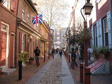 Elfreth's Alley, looking west toward 2nd Street.
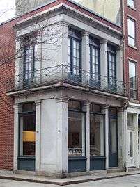 NW corner 3rd & Cherry Streets.
 Plaza at Pennsylvania Academy of the Fine Arts.
 Race Street Meeting House, NW corner 15th & Cherry Streets.
 Embassy Suites Hotel, NW corner Cherry Street & Benjamin Franklin Parkway.
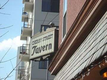 Cherry Street Tavern, NE corner 22nd & Cherry Streets.
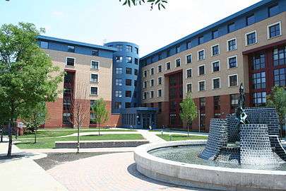 North Hall, Drexel University, NE corner 33rd & Cherry Streets.
See also
References
| Wikimedia Commons has media related to Cherry Street (Philadelphia). |
- ↑ Robert F. Looney, Old Philadelphia in Early Photographs, 1839–1913 (Courier, 2013).
- 1 2 Alotta, Robert I. (1990). Mermaids, Monasteries, Cherokees, and Custer: The Stories Behind Philadelphia Street Names. Chicago, IL: Bonus Books, Inc. p. 52. ISBN 9780933893900.
- ↑ Elfreth's Alley Archived February 26, 2015, at the Wayback Machine., from ushistory.org.
- ↑ "Historic Street Name Index".
- ↑ Stephan Salisbury, "Beneath Independence Mall, story of early free black America," The Philadelphia Inquirer, July 2, 2008.
Coordinates: 39°57′20″N 75°09′53″W / 39.955577°N 75.16475°W