Chabelley
| Chabelley Chebele | |
|---|---|
| Village | |
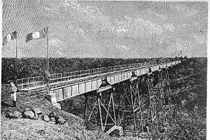 The old Ethio-Djibouti Railroad bridge at Chabelley in 1898 | |
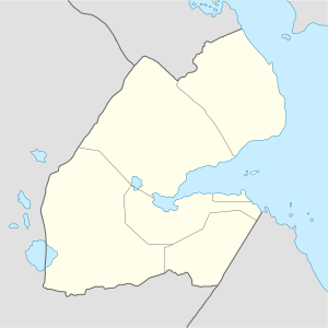 Chabelley Chebele Location in Djibouti | |
| Coordinates: 11°29′21″N 43°04′39″E / 11.48917°N 43.07750°ECoordinates: 11°29′21″N 43°04′39″E / 11.48917°N 43.07750°E | |
| Country |
|
| Region | Arta |
| Elevation | 142 m (466 ft) |
| Population 2012 | |
| • Total | 723 |
Chabelley (Somali: Chebele), (Arabic: شبيلي) is a village in the southern Arta region of Djibouti. It lies less than 13 km from the capital Djibouti City.
Demographics
As of 2012, Chabelley has a population of around 723 inhabitants. Most residents belong to various mainly Afro-Asiatic-speaking ethnic groups, with the Issa Somali predominant.
Transportation
The Ethio-Djibouti Railways passes through the village. Nearby towns and villages include Ali Sabieh (65 km), Goubetto (15 km), Ali Adde (55 km) and Holhol (29 km).
Some 1.5 miles north of Chabelley is Chabelley Airport, a desert airstrip until recently exclusively reserved in case of need for French military devices.[1] In September 2013, the airstrip began serving as a temporary hub for U.S. military unmanned aircraft from the nearby Camp Lemonnier Naval Expeditionary Base.[2]
Climate
| Climate data for Chabelley | |||||||||||||
|---|---|---|---|---|---|---|---|---|---|---|---|---|---|
| Month | Jan | Feb | Mar | Apr | May | Jun | Jul | Aug | Sep | Oct | Nov | Dec | Year |
| Average high °C (°F) | 27.1 (80.8) |
28.0 (82.4) |
29.8 (85.6) |
31.8 (89.2) |
34.2 (93.6) |
37.8 (100) |
40.5 (104.9) |
39.6 (103.3) |
36.2 (97.2) |
32.6 (90.7) |
30.2 (86.4) |
28.0 (82.4) |
33 (91.4) |
| Daily mean °C (°F) | 24.5 (76.1) |
25.1 (77.2) |
26.6 (79.9) |
28.4 (83.1) |
30.6 (87.1) |
33.8 (92.8) |
35.5 (95.9) |
34.4 (93.9) |
32.8 (91) |
28.9 (84) |
26.7 (80.1) |
24.9 (76.8) |
29.3 (84.8) |
| Average low °C (°F) | 21.0 (69.8) |
22.2 (72) |
23.4 (74.1) |
25.0 (77) |
27.1 (80.8) |
29.2 (84.6) |
29.9 (85.8) |
29.3 (84.7) |
29.1 (84.4) |
25.3 (77.5) |
23.2 (73.8) |
21.3 (70.3) |
25.5 (77.9) |
| Average rainfall mm (inches) | 13 (0.51) |
9 (0.35) |
15 (0.59) |
29 (1.14) |
19 (0.75) |
3 (0.12) |
7 (0.28) |
9 (0.35) |
10 (0.39) |
13 (0.51) |
26 (1.02) |
15 (0.59) |
168 (6.6) |
| Source: The Weather Channel | |||||||||||||
See also
Notes
- ↑ "La Corne de l'Afrique, enjeu stratégique majeur". Assajog. 17 November 2013. Archived from the original on 20 November 2013. Retrieved 20 November 2013.
- ↑ Craig Whitlock, Greg Miller (24 September 2013). "U.S. moves drone fleet from Camp Lemonnier to ease Djibouti's safety concerns". Washington Post. Retrieved 20 November 2013.