Chauve Souris, Mahé
| Nickname: Bat Island | |
|---|---|
 Chauve Souris Island Location of Chauve Souris Island in Seychelles | |
| Geography | |
| Location | Seychelles, Indian Ocean |
| Coordinates | 4°44′20″S 55°27′48″E / 4.73889°S 55.46333°ECoordinates: 4°44′20″S 55°27′48″E / 4.73889°S 55.46333°E |
| Archipelago | Inner Islands, Seychelles |
| Adjacent bodies of water | Indian Ocean |
| Total islands | 1 |
| Major islands |
|
| Area | 0.003 km2 (0.0012 sq mi) |
| Length | 0.05 km (0.031 mi) |
| Width | 0.05 km (0.031 mi) |
| Coastline | 0.1 km (0.06 mi) |
| Highest elevation | 9 m (30 ft) |
| Administration | |
| Group | Inner Islands |
| Sub-Group | Granitic Seychelles |
| Sub-Group | Mahe Islands |
| Districts | Baie Lazare |
| Demographics | |
| Population | 0 (2014) |
| Pop. density | 0 /km2 (0 /sq mi) |
| Ethnic groups | Creole, French, East Africans, Indians. |
| Additional information | |
| Time zone | |
| ISO code | SC-06 |
| Official website |
www |
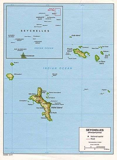
Chauve Souris is an island in Seychelles, lying 400 m west of Anse La Mouche on the island of Mahé. The island is a rocky granite island covered with tropical forest. There is also a Chauve Souris island near the northern coast of the island of Praslin.
Image gallery
 Map 1
Map 1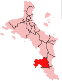 District Map
References
External links
This article is issued from
Wikipedia.
The text is licensed under Creative Commons - Attribution - Sharealike.
Additional terms may apply for the media files.