Charlotte station (Amtrak)
Charlotte, NC | ||||||||||||||||||||
|---|---|---|---|---|---|---|---|---|---|---|---|---|---|---|---|---|---|---|---|---|
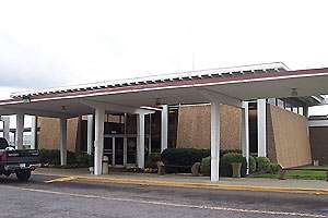 Station entrance | ||||||||||||||||||||
| Location |
1914 North Tryon Street Charlotte, North Carolina United States | |||||||||||||||||||
| Coordinates | 35°14′28.4″N 80°49′21.5″W / 35.241222°N 80.822639°WCoordinates: 35°14′28.4″N 80°49′21.5″W / 35.241222°N 80.822639°W | |||||||||||||||||||
| Owned by | Norfolk Southern Railway | |||||||||||||||||||
| Line(s) | Charlotte District | |||||||||||||||||||
| Platforms | 1 island platform | |||||||||||||||||||
| Tracks | 2 | |||||||||||||||||||
| Connections |
| |||||||||||||||||||
| Construction | ||||||||||||||||||||
| Structure type | At-grade | |||||||||||||||||||
| Parking | 80 spaces; free | |||||||||||||||||||
| Disabled access | Yes | |||||||||||||||||||
| Architect | Walter Hook Associates, Inc. | |||||||||||||||||||
| Architectural style | Mid-century modern | |||||||||||||||||||
| Other information | ||||||||||||||||||||
| Station code | CLT (Amtrak) | |||||||||||||||||||
| History | ||||||||||||||||||||
| Opened | 1962 | |||||||||||||||||||
| Original company | Southern Railway | |||||||||||||||||||
| Traffic | ||||||||||||||||||||
| Passengers (FY2017) |
168,144[1][2] | |||||||||||||||||||
| Services | ||||||||||||||||||||
| ||||||||||||||||||||
Charlotte is an Amtrak station located at 1914 North Tryon Street, about 1.5 miles (2.4 km) to the northeast of downtown Charlotte. It is the southern terminus for the Carolinian and Piedmont, as well as an intermediate stop on the Crescent. As of 2018, it is Amtrak's fifth-busiest station in the Southeast United States.
History
Opened in 1962, this was Charlotte's second station to be served by the Southern Railway. It was designed by local architectural firm Walter Hook Associates, Inc. The structure was designed to be constructed quickly and therefore included the use of an exposed precast concrete framing system. A separate mail building (freight depot) and boiler house were also constructed northeast of the station. The facility is smaller than its predecessor station on 531 West Trade Street, which was a response to the dramatically decrease of passenger rail service of that time. Southern Railway continued passenger rail service until 1979, when it was turned over to Amtrak. In 2002, with partnership with the North Carolina Department of Transportation (NCDOT), the station was expanded with additional space for the waiting area, additional ticket window and new benches that replaced the original wood furniture.[3] [4]
Predecessor stations
Seaboard Depot
Opened in June 1896, the Seaboard Depot (also referred as Seaboard station) was designed by Charles Hook and is located at 945 North College Street. The station was a replacement of an earlier station built by the Wilmington, Charlotte and Rutherfordton Railroad Company, from 1858-1895. The two-story pink stucco station offered white and colored waiting areas on the first floor, separated by a hallway and ticket office, toilet facilities and a baggage room; the second floor was dedicated to railroad use: an office and engineers' dormitory, conductors' and train master's rooms, telegraph room and convenience areas.[5][6]
Renovation to the station occurred in 1916-17, at a cost of $22,000. Drafted by Seaboard architects and constructed by A. M. Walkup Company of Richmond, Virginia; the facility was enlarged by adding one-story additions on both ends, a wide umbrella shed and facade changes. On November 1958, the station discontinued passenger service; the station was used afterwards as a yard office before being sold to Union Ministry Center.[5][6]
Richmond and Danville Depot
Built in 1886, the Richmond and Danville Depot was located on Trade Street on the east side of the downtown bypass tracks. Replacing the Atlanta & Charlotte depot, which was located same area but on opposite side of tracks, it was two-and-half-story with eaves on nearly all sides. The facility including two waiting rooms, ticket office, dining room, kitchen (2nd floor), telegram office, baggage area and a Southern Express Company (packaging services) office. In 1894, ownership changed to the Southern Railway Company; eleven years later the station was razed and replaced.[6][7][8][9]
Southern Depot

Opened in 1905, the Southern Depot (also referred as Southern Station) was designed by Frank Milburn and was located at 531 West Trade Street. Replacing the Richmond and Danville Depot, which was located in same area, the three-story Mediterranean style station had one side platform and one island platform operating on three tracks. The facility included waiting areas, ticket office and baggage facilities on the first floor; the second floor was dedicated to railroad use and a five-story tower. A separate two-story Southern Express Company (packaging services) building was located south adjacent to station, while the three-story Stonewall Hotel was located east adjacent to the station. Eaves on nearly all sides of the station, it also had a high arch going over two tracks, connecting with the island platform canopy.[6][10]
Because of a grade-separation project and the reduction in passenger service, the station was replaced in 1962 with the current Southern, and later Amtrak, station at 1914 North Tryon Street. Soon afterwards the station was razed, while two of the three tracks were raised to separate grade crossings with Fourth, Trade and Fifth streets. On November 1973, a Greyhound station was opened where the Southern Depot once stood, while unused land became car parking lots.[4][11][12]
Interurban Depot
Opened in July 1912, the Piedmont and Northern Railway Interurban Depot (also refereed as Interurban station) was located at 425 West Fourth Street, across from the Charlotte Mint. The rail line was electrified to 1,500 volts DC, connecting Charlotte to Mount Holly, Belmont and Gastonia. In 1951, passenger operations were discontinued and the depot was razed by 1970. The area remained dormant for decades, used on occasion for car parking and storage; in 2012, the land was redeveloped into the BB&T Ballpark[6][13][14][15]
Services
The station is served by three Amtrak routes: the Carolinian, the Crescent and the Piedmont. The facility includes the ticket office, passenger assistance, baggage service and a civic hall (waiting area). The facility is open 24 hours, which includes the ticket office, passenger assistance, baggage service and the waiting area. Free short and long-term parking is available.[16]
Station layout
The current station's exterior incorporates dark brown brick and large, angled concrete panels covered in pebble-dash. Interspersed with these heavy, solid elements are transparent walls of glass, which—coupled with clerestory windows beneath the roof—allow ample natural light to flood the 1,200-square-foot (110 m2) waiting room. In keeping with the aesthetics of Mid-Century Modern architecture, the station has minimal applied ornamentation.[4]
Future
The plan for passenger rail service in Charlotte is to return to Center City with the proposed Charlotte Gateway Station. To be located again along West Trade Street, it is to be an intermodal transit center linking inter-city Amtrak service with local bus, intercity bus, CityLynx Gold Line and taxi/ridesharing services. When completed, the current station will be closed.[17][18]
References
- ↑ "Amtrak Fact Sheet, FY2017, State of North Carolina" (PDF). Amtrak. November 2017. Retrieved 2 January 2018.
- ↑ "Amtrak Fact Sheet, FY2016, State of North Carolina" (PDF). Amtrak. November 2016. Retrieved 2 January 2018.
- ↑ Ward, Ralph. Southern Railway Depots, Vol. 1 North Carolina. Published by the author: Asheboro, NC. ISBN 0-9622999-1-X
- 1 2 3 "Charlotte, NC (CLT) - Great American Stations". Amtrak's Great American Stations. Retrieved May 7, 2018.
- 1 2 "Seaboard Air Line Railroad Passenger Terminal". Charlotte-Mecklenburg Historic Landmarks Commission. September 5, 1979. Retrieved May 6, 2018.
- 1 2 3 4 5 "Ten North Carolina Railroad Stations, a Yard Office, a Quartermasters Depot and a Trolley Shelter in Charlotte". Piedmont and Western Railroad Club. Retrieved May 6, 2018.
- ↑ Map of Charlotte, 1877 (Map). Cartography by Beers, Frederick W. New York, NY. 1911. Retrieved May 6, 2018.
- ↑ Charlotte, North Carolina, February 1885 (Map). New York, NY: Sanborn Map Company. February 1885. p. 2. Retrieved May 6, 2018.
- ↑ Charlotte, North Carolina, June 1890 (Map). New York, NY: Sanborn Map Company. June 1890. p. 3. Retrieved May 6, 2018.
- ↑ Charlotte, North Carolina, 1911 (Map). New York, NY: Sanborn Map Company. 1911. p. 60. Retrieved May 6, 2018.
- ↑ David, Maria (September 29, 2015). "Railway station to Greyhound terminal". The Charlotte Observer. Retrieved May 6, 2018.
- ↑ "6th Street Bridge". Lost Charlotte. February 1, 2015. Retrieved May 6, 2018.
- ↑ Official map of Charlotte, N.C. (Map). Cartography by Office of City Engineer. New York, NY: City of Charlotte. 1935. Retrieved May 6, 2018.
- ↑ "Piedmont and Northern...Yesterday and Today part i". WVNC Rails. Retrieved May 6, 2018.
- ↑ "The Piedmont and Northern Railway: "The Great Electrified System Of The South"". American Rails.com. Retrieved May 6, 2018.
- ↑ "Charlotte, North Carolina Train Station (CLT) - Amtrak". Retrieved May 6, 2018.
- ↑ Rainey, Amy (January 16, 2008). "The Ever-Changing Face of the Queen City - Here's the Scoop on Some Projects Going Up, In and Around Your Neighborhood". The Charlotte Observer. p. 10Z.
- ↑ "Gateway Station Home". City of Charlotte. Retrieved May 7, 2017.