Charles C. Glover Memorial Bridge
| Charles C. Glover Memorial Bridge | |
|---|---|
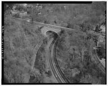 Aerial view of the Charles C. Glover Memorial Bridge | |
| Coordinates | 38°55′04″N 77°03′30″W / 38.9179°N 77.0583°WCoordinates: 38°55′04″N 77°03′30″W / 38.9179°N 77.0583°W |
| Carries | Massachusetts Avenue |
| Crosses | Rock Creek |
| Locale | Northwest Washington, D.C. |
| Official name | Massachusetts Avenue Bridge |
| Named for | Charles C. Glover |
| Heritage status | Historic American Engineering Record in Washington, D.C. |
| Characteristics | |
| Total length | 386.2 ft |
| History | |
| Architect | Louis Justement |
| Construction end | 1941 |
Coordinates: 38°55′04″N 77°03′30″W / 38.9178892°N 77.0583107°W The Charles C. Glover Memorial Bridge or Massachusetts Avenue Bridge in Northwest Washington, D.C. conveys Massachusetts Avenue over Rock Creek and Rock Creek Park. The concrete arch bridge was constructed in 1939–41 [1] and has a length of 386.2 feet.[1]
History and name
A much smaller iron truss bridge was built at the bottom of the valley in 1888, following the decision to extend Massachusetts Avenue beyond Florida Avenue. In 1901, this bridge was replaced with a land fill, with Rock Creek channeled through a large culvert.[2]
This in turn became inconvenient when Rock Creek Parkway was built in the 1930s. The construction of the bridge also allowed the level of Massachusetts Avenue to be raised significantly compared with the earlier bridge and land fill.
The bridge was named after Charles Carroll Glover, who had played a decisive role in shaping this area of Northwest Washington and who died in 1936.
On November 20, 1946, Stephen Norman, grandson of Theodor Herzl, jumped off the bridge to his death three weeks after learning that his whole family had died in the Holocaust.[3]
See also
References
- 1 2 Historic Bridges of the U.S. | Massachusetts Avenue Bridge
- ↑ Emily Hotaling Eig and Julie Mueller, Traceries (1989). "National Register of Historic Places Registration Form: Sheridan-Kalorama Historic District".
- ↑ http://www.haaretz.com/hasen/spages/931424.html
External links
| Wikimedia Commons has media related to Charles C. Glover Memorial Bridge. |
- Historic American Engineering Record (HAER) No. DC-22, "Massachusetts Avenue Bridge"
- Massachusetts Avenue Bridge at Structurae. Retrieved on 2012-12-24.