Chanute Peak
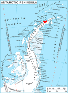
Location of Davis Coast.
Chanute Peak (63°56′S 59°58′W / 63.933°S 59.967°WCoordinates: 63°56′S 59°58′W / 63.933°S 59.967°W) is a peak in Korten Ridge on the east side of Lanchester Bay, 4 nautical miles (7 km) south of Wennersgaard Point, Davis Coast in Graham Land. It was named by the UK Antarctic Place-Names Committee for Octave Chanute, an American designer of gliders who first introduced moveable planes for the purpose of control and stability in 1896–97.[1]
Map
- Trinity Peninsula. Scale 1:250000 topographic map No. 5697. Institut für Angewandte Geodäsie and British Antarctic Survey, 1996.
References
- ↑ "Chanute Peak". Geographic Names Information System. United States Geological Survey. Retrieved 2011-11-02.
![]()
This article is issued from
Wikipedia.
The text is licensed under Creative Commons - Attribution - Sharealike.
Additional terms may apply for the media files.