Changping Township, Fusui County
| Changping 昌平乡 | |
|---|---|
| Township | |
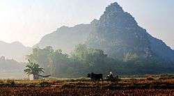 Changping scenery | |
| Coordinates: 22°42′33″N 107°53′47″E / 22.70917°N 107.89639°ECoordinates: 22°42′33″N 107°53′47″E / 22.70917°N 107.89639°E | |
| Country | People's Republic of China |
| Region | Guangxi |
| Prefecture-level city | Chongzuo |
| County | Fusui |
| Village-level divisions |
1 residential communities 8 villages |
| Area | |
| • Total | 196 km2 (76 sq mi) |
| Population (2011) | |
| • Total | 25,054 |
| • Density | 130/km2 (330/sq mi) |
| Time zone | UTC+8 (China Standard) |
| Postal code | 532101 |
Changping (simplified Chinese: 昌平乡; traditional Chinese: 昌平鄉; pinyin: Chāngpíng Xiāng; zhuang: Canghbingz Yangh) is a Township under the administration of Fusui County in southern Guangxi Zhuang Autonomous Region, China.[1] As of 2011, it had an area of 196 square kilometres (76 sq mi) populated by 25,054 people residing in 1 residential communities (社区) and 8 villages.[2]
Administrative divisions
There are 1 residential communities and 8 villages:
Residential communities:
- Changping (昌平社区)
Villages:
- Sairen(赛仁村), Mumin(木民村), Pingbai(平白村), Balian(八联村),Lianhao(联豪村),Sihe(四和村), Shili(石丽村), Zhonghua(中华村)
See also
References
- ↑ "Fusui statistics 2011" (in Chinese). National Bureau of Statistics of the People's Republic of China. Archived from the original on 2012-07-21. Retrieved 2013-01-08.
- ↑ "Changping Township statistics 2011" (in Chinese). National Bureau of Statistics of the People's Republic of China. Retrieved 2013-01-03.
External links
- Changping Township/Official website of Changping(in Chinese)
This article is issued from
Wikipedia.
The text is licensed under Creative Commons - Attribution - Sharealike.
Additional terms may apply for the media files.