Chalk Farm
| Chalk Farm | |
|---|---|
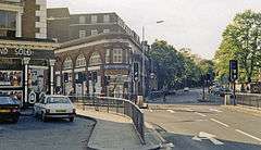 Junction of Adelaide Road and Haverstock Hill, outside Chalk Farm Underground station | |
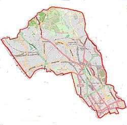
 Chalk Farm Chalk Farm shown within Greater London | |
| Population | 24,977 Informal tube-named district: maximal two-ward definition based on 2011 census[1] |
| OS grid reference | TQ2884 |
| London borough | |
| Ceremonial county | Greater London |
| Region | |
| Country | England |
| Sovereign state | United Kingdom |
| Post town | LONDON |
| Postcode district | NW1, NW3, NW5 |
| Dialling code | 020 |
| Police | Metropolitan |
| Fire | London |
| Ambulance | London |
| EU Parliament | London |
| UK Parliament | |
| London Assembly | |
Chalk Farm is a small urban district of northwest London, England immediately north of Camden Town and currently split equally between the electoral wards of Camden Town and Primrose Hill in the south and Haverstock in the north.
Geography
The land slopes upwards more steeply to the north-west and abruptly to form a knoll to the south-west which is Primrose Hill. Chalk Farm Underground station is the closest underground network station to all parts if that is the defining criterion. The same is true of much of the upmarket western residential definition and green (Regents Park definition) of Primrose Hill that is more associated with Chalk Hill. The south of the area has regular residents on its broadest definition, which is capable of including Jude Law, Sadie Frost and Sienna Miller among the highest-grossing early 21st century 'Camden set' of writers, artists and actors, but equally, parts of both wards have some stubborn poverty and a significant minority of their housing is social housing.
History
Its name was formerly Chalcot when it was a hamlet of the once vast Hornsey parish (centred on a village of the same name). Before the post-1791 development of Camden Town, the residents of Primrose Hill who did not live on the green hill were divided between Hornsey and St Pancras villages. It is in this vein that many residents of Primrose Hill seek alternatives to being considered part of Camden, however under the London Government Act 1963, Camden became the overall name for the borough and a convenient, neutrally loaded term for all inchoate and non-historic districts by being of carefully planned late Georgian origin rather than named after the London Underground network which has seen various changes to station names and debatable associations with stations.[2]
Economy
Chalk Farm equates to the northern neighbourhood of Camden Town and features many lively pubs, live music venues, and restaurants.
Within immediate reach of the tube station is The Roundhouse, a former circular railway engine turntable shed converted to 360° arts and performance use.
Chalk Farm contains Haverstock School Business & Enterprise College (formerly Haverstock Comprehensive School).
Camden College of English was in Chalk Farm
For over 70 years major bus routes were operated from Chalk Farm bus garage, in Harmood Street, now long gone. Today the long-established route 27 and the newer route 393 both terminate at Chalk Farm. These buses reach opposite destinations outside central London: Chiswick Business Park and Clapton respectively.
Walden Books is a long-established secondhand bookshop located just off Chalk Farm Road.
Demography
Being a convenient division ('district') with no formal definition, the maximal definition of Chalk Farm takes in the bulk of two current electoral wards which are set out below, with relevant land use and home ownership statistics from the 2011 census.
| Output area | Homes owned outright | Owned with a loan | Socially rented | Privately rented | Other | km² green spaces | km² roads | km² water | km² domestic gardens | km² domestic buildings | km² non-domestic buildings | Usual residents | km² |
|---|---|---|---|---|---|---|---|---|---|---|---|---|---|
| Haverstock ward | 677 | 727 | 2583 | 1156 | 111 | 0.10 | 0.01 | 0.00 | 0.15 | 0.10 | 0.08 | 12364 | 0.73 |
| Camden Town with Primrose Hill ward | 1122 | 882 | 1802 | 1974 | 125 | 0.16 | 0.02 | 0.02 | 0.18 | 0.15 | 0.17 | 12613 | 1.17 |
Transport
Neighbouring places
- Primrose Hill
- Camden Town
- Regent's Park
- Kentish Town
- Maitland Park
- St John's Wood
- Swiss Cottage
Nearest stations
- Chalk Farm on the north-south Northern line, Edgware branch.
The nearest London Overground station (east-west) is centred 0.5 miles (0.80 km) east:
References
- 1 2 Key Statistics: Dwellings; Quick Statistics: Population Density; Physical Environment: Land Use Survey 2005
- ↑ Edward Walford (1878). Old and New London: Vol. 5. Retrieved 9 August 2011.