Conway Reef
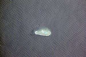
Conway Reef, known since 1976 by its Fijian name Ceva-I-Ra Reef, (pronounced [ˈðeβaiˈra]), is a coral reef of atoll type 450 km southwest of the Fiji Islands and part of the Republic of Fiji. It is at 21°44′18″S 174°38′24″E / 21.73833°S 174.64000°E.[1] It is 2.5 km long in an east-west direction. On the middle of the reef is a small sand cay, 1.8 meters high and about 320 metres long and 73 metres wide, with a land area of two hectares. A stranded wreck of a coaster lies 240 metres south of the centre of the cay, and the wreck of a fishing vessel (Sang Sheng No. 168) lies on the northeast end of the reef.[2] The reef is uninhabited apart from birds which appear to have almost no fear of humans. Administratively, the reef is part of the Western Division, Fiji and of the Nadroga-Navosa province.
In 1838 the Royal Navy Captain Drinkwater Bethune of HMS Conway first came across the reef and recorded it; it was first mapped by the British several years later by Captain Denham of HMS Herald. Three recent shipwrecks (1979, 1981 and 2008) have occurred on the reef, the latest being a Chinese fishing vessel (San Sheng No. 168). There were earlier wrecks, for instance the brig Rapid, under Captain Arthur Devlin, ran aground on the reef at 0200 h on 14 January 1841, making 7 knots with every stitch of sail set, the lookout having been set but apparently not kept. Later, the ship Logan, of New Bedford, under Captain Wells, was wrecked on “Sandy Island Reef” {Conway Reef} on the night of 26 January 1855.[3]
It was reported in 1983 that there was some vegetation on the cay, but it was bare by 1985. The cay currently has some vegetation about 3m high.
While there are no other gaps larger than 75 km between the Fiji islands (except Rotuma Island, which is politically but not geographically part of Fiji), Conway Reef lies 450 km to the southwest of the main Fiji complex. The closest land to Conway Reef lies 275 km WSW, namely Hunter Island in the French territory of New Caledonia. Hunter Island is also claimed by Vanuatu.
Access to the island should only be attempted at high tide in a shallow draft tender. Extreme care must be taken to navigate the coral heads.
Diving or snorkeling on the reef is the rare experience of an untouched underwater environment. The island counts as a separate entity for DXCC credit in amateur radio, and several Dxpeditions have visited it. The last one was in September 2012.[4]
References
- ↑ Fiji's 1981 maritime limits claim published by the UN
- ↑ http://permanent.access.gpo.gov/websites/pollux/pollux.nss.nima.mil/NAV_PUBS/SD/pub126/126sec05.pdf
- ↑ Ward 1967.
- ↑ Conway Reef DX-pedition 2012, 3D2C
Coordinates: 21°44′18″S 174°38′24″E / 21.73833°S 174.64000°E