Cessange
Cessange
| |
|---|---|
| Quarter | |
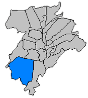 Cessange is one of 24 quarters in Luxembourg City | |
| Coordinates: 49°35′17″N 6°06′15″E / 49.58806°N 6.10417°ECoordinates: 49°35′17″N 6°06′15″E / 49.58806°N 6.10417°E | |
| Country | Luxembourg |
| Commune | Luxembourg City |
| Area[1] | |
| • Total | 6.58 km2 (2.54 sq mi) |
| Population (2017)[2] | |
| • Total | 4,330 |
| • Density | 660/km2 (1,700/sq mi) |
| Nationality[2] | |
| • Luxembourgish | 36% |
| • Other EU citizens | 55.2% |
| • Other | 8.8% |
| Website | Cessange |
Cessange (Luxembourgish: Zéisseng, German: Zessingen) is a quarter in south-western Luxembourg City, in southern Luxembourg.
Most of the quarter is covered by open fields to the south-west of Luxembourg City proper. At the centre of the quarter is the Croix de Cessange: a motorway junction between the A4 and the A6. Next to the intersection is Stade Boy Konen, which plays host to FC CeBra 01, Rugby Club Luxembourg, and the Luxembourg national rugby union team.
Population
As of 2017, Cessange had a population of 4,330 inhabitants, 36% of whom were of Luxembourgish nationality, 55.2% of whom were of other European Union (EU) nationalities, and the remaining 8.8% possessing no EU nationality.[2]
Gallery
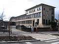 The primary school
 The water tower
 The cultural center
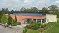 The sports center
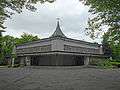 The catholic church
.JPG) The local brook
The local brook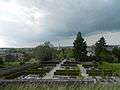 The cemetery
References
- ↑ "Cessange". www.vdl.lu (in French). Ville de Luxembourg. Retrieved 15 June 2018.
- 1 2 3 "Statisiques sur la Ville de Luxembourg: Etat de Population - 2017" (PDF). www.vdl.lu (in French). Ville de Luxembourg. p. 21. Retrieved 15 June 2018.
This article is issued from
Wikipedia.
The text is licensed under Creative Commons - Attribution - Sharealike.
Additional terms may apply for the media files.