Cerros de Incahuasi
| Cerros de Incahuasi | |
|---|---|
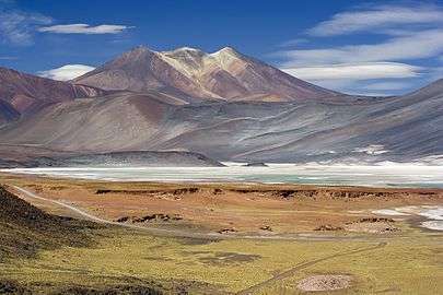 Salar de Talar with Cerros de Incahuasi in the background | |
| Highest point | |
| Elevation | 5,704 m (18,714 ft) [1] |
| Coordinates | 24°02′S 67°33′W / 24.033°S 67.550°W [2] |
| Geography | |
| Location | Chile |
| Country |
|
| Parent range | Andes |
Cerros de Incahuasi is a mountain with several summits located in the Antofagasta Region of Chile, near Sico Pass.
The Incahuasi Sur volcano in this range was active 10.5 million years ago. It is associated with a volcanic belt and fault that extends southeastward from Incahuasi Sur, the Calama–Olacapato–El Toro fault.[3]
See also
References
- ↑ "Archived copy". Archived from the original on 2007-09-29. Retrieved 2007-03-30.
- ↑ "Archived copy". Archived from the original on 2012-05-04. Retrieved 2010-06-27.
- ↑ Petrinovic, Ivan Alejandro; Riller, Ulrich; Brod, José Affonso (February 2005). "The Negra Muerta Volcanic Complex, southern Central Andes: geochemical characteristics and magmatic evolution of an episodically active volcanic centre". Journal of Volcanology and Geothermal Research. 140 (4): 295–320. doi:10.1016/j.jvolgeores.2004.09.002.
This article is issued from
Wikipedia.
The text is licensed under Creative Commons - Attribution - Sharealike.
Additional terms may apply for the media files.