Cerro de Gorría
| Cerro de Gorría | |
|---|---|
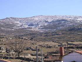 Winter view from Pasarilla del Rebollar | |
| Highest point | |
| Elevation | 1,708[1] m (5,604 ft) |
| Coordinates | 40°39′25″N 04°59′03″W / 40.65694°N 4.98417°WCoordinates: 40°39′25″N 04°59′03″W / 40.65694°N 4.98417°W |
| Geography | |
 Cerro de Gorría Spain | |
| Location | Ávila Province, Castile and León |
| Parent range | Sierra de Ávila |
| Geology | |
| Mountain type | Granite[2] |
| Climbing | |
| First ascent | ancestral |
| Easiest route | hike |
Cerro de Gorría is a 1.708 metres high mountain in Spain.
Geography
The mountain is located in Ávila Province, in the southern part of the autonomous community of Castile and León. It's the highest peak of the Sierra de Ávila, and is visible from a large part of the province.
Access to the summit
The summit can be accessed in one hour's walk from Pasarilla del Rebollar (1300 m, Valdecasa municipality). Its summit offers an interesting view on la Moraña, Amblés valley, Sierra Paramera, and la Serrota.[3] In a clean day also Sierra de Guadarrama can be seen in the distance.
See also
References
- ↑ "Principales cumbres montañosas de la provincia de Ávila". www.ign.es (in Spanish). Instituto Geográfico Nacional. Retrieved March 20, 2015.
- ↑ El medio rural español: cultura, paisaje y naturaleza : homenaje a don Angel Cabo Alonso, Volume 2 (in Spanish). Universidad de Salamanca. Retrieved March 20, 2015.
- ↑ "Pasarilla del Rebollar". jim3cantos.tripod.com/pasarilla (in Spanish). Retrieved March 20, 2015.
External links
- (in Spanish) Route to Cerro de Gorría from Balbarda
This article is issued from
Wikipedia.
The text is licensed under Creative Commons - Attribution - Sharealike.
Additional terms may apply for the media files.