Cerro San Luis Obispo
| Cerro San Luis Obispo | |
|---|---|
 Cerro San Luis Obispo (left) | |
| Highest point | |
| Elevation | 1,292 ft (394 m) NGVD 29[1] |
| Coordinates | 35°16′58″N 120°40′50″W / 35.2827524°N 120.6804498°WCoordinates: 35°16′58″N 120°40′50″W / 35.2827524°N 120.6804498°W [2] |
| Naming | |
| Translation | Bishop Saint Louis Hill (Spanish) |
| Geography | |
| Location | San Luis Obispo County, California, U.S. |
| Parent range | Santa Lucia Range |
| Topo map | San Luis Obispo |
| Geology | |
| Age of rock | 20 million years |
| Mountain type | Volcanic plug |
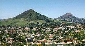
Cerro San Luis Obispo is a 1,292 feet (394 m) mountain in San Luis Obispo, California.[2] It is part of the chain of peaks called the Nine Sisters. It is colloquially and traditionally referred to as "San Luis Mountain" and sometimes incorrectly as "Mount San Luis", "Madonna Mountain" or "Mission Mountain". It is a common spot for hiking, jogging and mountain biking, and has steep terrain.[3] Below the west side of the visible peak, there is a large plateau with a large wooden stage on the east end. The large white "M" present on the east face derives from Mission Central Catholic High School.
History
Some time around 1900, an American Civil War veteran, G. W. Chandler, lived on the mountain and planted lemons and oranges. The trees still overlook the city and are watered by two springs. The Lemon Grove Trail at the base of the mountain takes its name from these groves.[4]
Around 1958, a local business owner, Alex Madonna, purchased a ranch on a portion of the slopes of Cerro San Luis Obispo, and constructed the Madonna Inn at its base.[5]
Activities
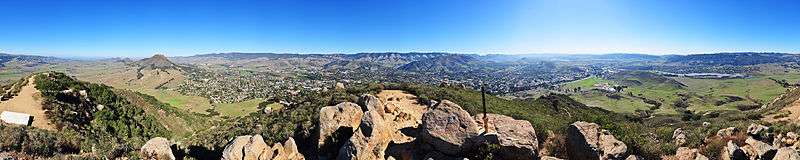
There are several trails on the mountain that are used for hiking, jogging and mountain biking. The primary trail head is at the end of Marsh Street which provides access to the Open Space and Lemon Grove Loop. A dirt road accessible from Lemon Grove Loop leads to the summit. There is a second road cut to the summit which has been abandoned and eroded to a narrow rocky path giving it the name "Rock Garden" and making it a popular descent for mountain bikers. There is also a trail that encircles the mountain about one third the way up.
Correct and Incorrect Alternate Names
The correct name for this peak is "Cerro San Luis Obispo"/"Cerro San Luis". Historically this peak has long been known as "San Luis Mountain" and it still often referred to by that name. The peak is also incorrectly referred to as "Madonna Mountain", "Mission Mountain" or rarely "Mount San Luis." Some confusion may derive from the "M" placed on the side of the mountain [by students from (M)ission Central Catholic High School in 1966, now Mission College Preparatory Catholic School] and its proximity to Old (M)ission San Luis Obispo de Tolosa. Others incorrectly refer to San Luis Mountain as "Madonna Mountain" because much of the surrounding land as well as land at the summit is actually owned by the Madonna Family of San Luis Obispo.
References
- ↑ "Cerro San Luis, California". Peakbagger.com.
- 1 2 "Cerro San Luis Obispo". Geographic Names Information System. United States Geological Survey. Retrieved 2009-12-20.
- ↑ Billings, Victoria; Sepulveda, Tom (August 29, 2016). "Hike of the Week: Cerro San Luis". The Tribune (San Luis Obispo). Retrieved 11 July 2017.
- ↑ "Cerro San Luis". Eco SLO. Archived from the original on 2008-05-09. Retrieved 2009-12-20.
- ↑ "The Nine Sisters of San Luis Obispo County". Santa Lucia Chapter, Sierra Club. Retrieved 2016-12-28.