Cerro Rico
| Cerro Rico | |
|---|---|
| Cerro Potosí / Sumaq Urqu | |
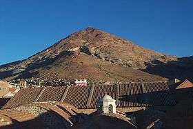 View of Cerro Rico from Potosí | |
| Highest point | |
| Elevation | 4,782 m (15,689 ft) |
| Coordinates | 19°37′8″S 65°44′59″W / 19.61889°S 65.74972°WCoordinates: 19°37′8″S 65°44′59″W / 19.61889°S 65.74972°W |
| Geography | |
 Cerro Rico Location in Bolivia | |
| Location | Bolivia, Potosí |
| Parent range | Andes |
Cerro Rico (Spanish for "rich mountain"), Cerro Potosí[1] ("Potosí mountain") or Sumaq Urqu[2] (Quechua sumaq beautiful, good, pleasant, urqu mountain,[3] "beautiful (good or pleasant) mountain") is a mountain in the Andes near the Bolivian city of Potosí. Cerro Rico, which is popularly conceived of as being "made of" silver ore, was famous for providing vast quantities of silver for Spain during the period of the New World Spanish Empire. It is estimated that eighty-five percent of the silver produced in the central Andes during this time came from Cerro Rico.[4] As a result of mining operations in the mountain, the city of Potosí became one of the largest cities in the New World.[5]
After 1800, the silver mines were depleted, leaving far less valuable tin as the mine's main product. This eventually led to a slow economic decline.[6] At the start of the 20th century, liberal reforms and an increase in government policies favoring foreign investment led to a decrease in nationalization of natural resources and an increase in ownership by private companies. Almost immediately following the change in Peruvian mining code in 1901 that allowed for the privatization of mines, a New York-based company purchased "80 per cent of the mines in the Cerro de Pasco region of the central andes".[5]
The newly formed Cerro de Pasco Corporation pursued immediate large-scale extractive mining, which contributed to a long-term change in the local eco-system. The need for large quantities of timber to build the mining infrastructure necessary to extract minerals, also caused high amounts of erosion and deforestation. Dams needed to produce electricity for this massive private project caused floods, which altered the land and damaged the natural environment. After centuries of extractive mining methods that severely damaged the local ecology the mountain continues to be mined for silver to this day. Due to poor worker conditions, such as a lack of protective equipment against the constant inhalation of dust, many of the miners contract silicosis and have a life expectancy of around 40 years. The mountain is still a significant contributor to the city's economy, employing some 15,000 miners.
It is known as 'mountain that eats men' because of the large number of workers who died in the mines. Some writers such as Eduardo Galeano, in his work Open Veins of Latin America, estimates that up to 8 million have died in the Cerro Rico since the 16th century. Though this number has been attributed to the entirety of the Viceroyalty of Peru by Josiah Conder,[7] who added that these numbers also take into account any depopulation of areas around mines. The work of historians such as Peter Bakewell,[8] Noble David Cook,[9] Enrique Tandeter [10] and Raquel Gil Montero [11] portray a more accurate description of the human-labor issue (free and non-free workers) with completely different estimations.
As a result of centuries long mining, in 2011 a sinkhole in the top appeared and had to be filled with ultra-light cement. The summit also continues to sink a few centimetres every year.[12] In 2014, UNESCO added Cerro Rico and Potosí to its list of endangered sites, owing to "uncontrolled mining operations" that risk "degrading the site".
Bolivian Mining Cooperative
Bolivia's cooperative mining sector, whose center is in Potosi, has been given many privileges included favorable tax treatment and exemption from labor and environmental regulations since the election of socialist president Evo Morales in 2006. After centuries of brutal Spanish extraction and forced labor, decades of foreign control and private investment in the late 20th century, and the failure of the state-run mining company COMIBOL led to the displacement of 25,000 miners following plummeting mineral prices in the 1990s, "informal, self-managed associations" began selling "unrefined product to private operators".[13]
FENCOMIN (National Federation of Mining Cooperatives in Bolivia) was a vital player in insuring the successful popular election of Evo Morales and also functioned as one of the leaders in drafting Bolivia's new constitution establishing a plural mining economy (state, private, and cooperative). However, over the last ten years much conflict has arisen between cooperative miners and state miners. In 2006, state miners and cooperatives clashed at Huanuni leaving 16 dead leading to the firing of Morales' first Mining Minister, a member of FENCOMIN. Most recently in 2016, Bolivia's Deputy Interior Minister Rodolfo Ilanes was tortured and killed, allegedly by a Bolivian mining cooperative. This outburst of violence has led to clashes between cooperative miners and the police leaving five miners dead and severing a decade of strong ties between cooperative mining and the Morales government.[13]
Mine
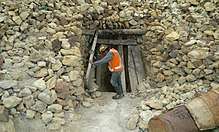
Cerro Rico de Potosí was accidentally discovered in 1545 by Diego de Huallpa, a Quechua Indian and native Peruvian silver miner for Spanish overseers, while he was searching the mountain for an Inca shrine or traditional burial offering.[14] The red mountain, now known as Cerro Rico, sits nestled between Porco and Sucre mines which had previously been discovered being at lower altitudes and therefore easier to mine. However, once Cerro Rico was found to carry predominantly silver ores, mining focus shifted to the harvesting of the more costly ore over ores like tin, zinc, and lead found in Porco and Sucre. Now one of the largest silver mines in Bolivia, and in the world, the Cerro Rico de Potosí mine has estimated reserves of 1.76 billion ounces of silver and 540 million tons of ore grading 0.17% tin.[15] The mine is located in the south of the country in Potosí Department.[15]
See also
References
- ↑ Bolivian IGM map 1:50,000 Potosí (Oeste) 6435-III
- ↑ Roberto Choque Canqui, Jesús de Machaqa, La marka rebelde, Cinco siglos de historia, Cuadernos de Investigación 45, La Paz, Bolivia, 2003
- ↑ Teofilo Laime Ajacopa, Diccionario Bilingüe Iskay simipi yuyayk'ancha, La Paz, 2007 (Quechua-Spanish dictionary)
- ↑ Weatherford, Jack (2010) [1st pub 1988]. Indian givers : how Native Americans transformed the world (2nd ed.). New York, N.Y.: Three Rivers Press. p. 6. ISBN 9780307717153. OCLC 656265477.
- 1 2 DORE, ELIZABETH (2000). "Environment and Society: Long-Term Trends in Latin American Mining". Environment and History. 6 (1): 1–29. doi:10.2307/20723118 (inactive 2018-01-22). JSTOR 20723118.
- ↑ Weatherford 2010, p. 25.
- ↑ "Modern Traveler". London: J.Duncan. 1830.
- ↑ Bakewell, Peter "Miners of the Red Mountain: Indian Labor in Potosi, 1545–1650". University of New Mexico Press 2010"
- ↑ Demographic Collapse: Indian Peru, 1520–1620 (Cambridge Latin American Studies)
- ↑ Tandeter, Enrique. "Coaccion y mercado. La mineria de plata en el Potosi colonial, 1692–1826". Siglo XXI Editores 2001.
- ↑ "Free and Unfree Labour in the Colonial Andes" (PDF). Instituto Superior de Estudios Sociales (CONICET-UNT), Tucuman. 2011.
- ↑ https://www.theguardian.com/world/2014/jan/10/bolivia-cerro-rico-mountain-sink-city-potosi
- 1 2 "What's Behind Bolivia's Cooperative Mining Wars?". NACLA. Retrieved 2017-12-02.
- ↑ Lane, Kris (2015-05-04). "Potosí Mines". doi:10.1093/acrefore/9780199366439.001.0001/acrefore-9780199366439-e-2 (inactive 2018-01-22).
- 1 2 "Metallogeny of Bolivia" (PDF). uchile.cl. 2013. Retrieved 2013-07-21.