Cerro Pachón
| Cerro Pachón | |
|---|---|
 Cerro Pachón | |
| Highest point | |
| Elevation | 2,715 m (8,907 ft) |
| Coordinates | 30°14′26.6″S 70°44′11.7″W / 30.240722°S 70.736583°WCoordinates: 30°14′26.6″S 70°44′11.7″W / 30.240722°S 70.736583°W |
| Geography | |
| Location | Chile |
| Parent range | Andes |
Cerro Pachón (Spanish for "Pachón hill") is a mountain located close to Chilean city of Vicuña and 10 km southeast of the Cerro Tololo Inter-American Observatory, at an altitude of 2,715 m over the sea level in the foothills of the Andes. The location is exceedingly dry, making it suitable for infrared observations. The air overhead is very stable, yielding excellent seeing. During the summer months, Cerro Pachón is often above the haze layer that can envelop lower altitudes.
There are currently two telescopes commissioned on Cerro Pachón, Gemini South and the Southern Astrophysical Research Telescope. A third, the Large Synoptic Survey Telescope, is under construction.
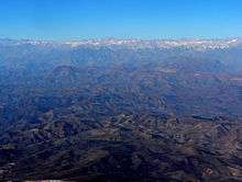
Wide view observatories from the air, including Cerro Pachón. In the distance are the Andes
External links
This article is issued from
Wikipedia.
The text is licensed under Creative Commons - Attribution - Sharealike.
Additional terms may apply for the media files.