Cerro El Pital
| Cerro El Pital | |
|---|---|
 | |
| Highest point | |
| Elevation | 2,730 m (8,960 ft) [1] |
| Prominence | 1,530 m (5,020 ft) [1] |
| Listing |
Country high point Ultra |
| Coordinates | 14°23′00″N 89°07′00″W / 14.38333°N 89.11667°WCoordinates: 14°23′00″N 89°07′00″W / 14.38333°N 89.11667°W [1] |
| Geography | |
 Cerro El Pital Location of Cerro El Pital in El Salvador on the border with Honduras | |
| Location |
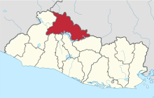
Chalatenango, El Salvador - Ocotepeque, Honduras[1] |
| Parent range | Sierra Madre |
Cerro El Pital is a mountain in Central America, on the border of El Salvador and Honduras. It is located 12 km (7 mi) from the town of La Palma at a height of 2,730 m (8,957 ft) above sea level, and is the highest point in Salvadoran territory. Cerro El Pital is in the middle of a cloud forest that has an average annual temperature of 10 °C (50 °F).[2]
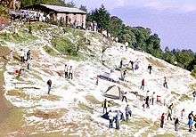
It is one of the most popular tourist draws in El Salvador, with great biodiversity in a wide altitudinal range containing many endangered species of flora and fauna. The cloud forest has some of the rarest plants and animals in the country, including quetzals and other endangered species.
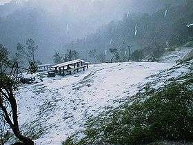
From November to February the temperature ranges between −6 °C (21 °F) and 10 °C (50 °F) (lowest recorded, in January 1956) and in the rest of the year the temperature ranges between 5 °C (41 °F) and 20 °C (68 °F). It is the coldest place in El Salvador. On 13 April 2004, much of the mountain was blanketed by an accumulation of hail during a storm, an unusual event that caused a commotion among the local community.[3]
Climate
| Climate data for Cerro El Pital, Chalatenango, El Salvador | |||||||||||||
|---|---|---|---|---|---|---|---|---|---|---|---|---|---|
| Month | Jan | Feb | Mar | Apr | May | Jun | Jul | Aug | Sep | Oct | Nov | Dec | Year |
| Daily mean °C (°F) | 8.5 (47.3) |
10.2 (50.4) |
12.5 (54.5) |
13 (55) |
14 (57) |
15 (59) |
15 (59) |
14 (57) |
12 (54) |
10 (50) |
8.1 (46.6) |
6.8 (44.2) |
11 (52) |
| Average low °C (°F) | −2.9 (26.8) |
−1.8 (28.8) |
−0.9 (30.4) |
1.0 (33.8) |
3.0 (37.4) |
3.0 (37.4) |
5.1 (41.2) |
5.8 (42.4) |
5.1 (41.2) |
3.4 (38.1) |
1 (34) |
−2.9 (26.8) |
4 (39) |
| Record low °C (°F) | −6.2 (20.8) |
−4.2 (24.4) |
−5.5 (22.1) |
−4.5 (23.9) |
0 (32) |
1 (34) |
1 (34) |
0 (32) |
−2.5 (27.5) |
−2.5 (27.5) |
−4.8 (23.4) |
−6 (21) |
−3.1 (26.4) |
| Average precipitation mm (inches) | 10.0 (0.394) |
20.0 (0.787) |
10.0 (0.394) |
6.0 (0.236) |
152.0 (5.984) |
242.0 (9.528) |
266.0 (10.472) |
286.0 (11.26) |
290.0 (11.417) |
217.0 (8.543) |
36.0 (1.417) |
10.0 (0.394) |
1,534 (60.39) |
References
- 1 2 3 4 "Cerro El Pital, El Salvador/Honduras". Peakbagger.com. Retrieved 17 February 2009.
- ↑ "Cerro El Pital" (in Spanish). Ministerio de Turismo de la República de El Salvador. 2005. Archived from the original on 2 May 2006. Retrieved 17 February 2009.
- ↑ Villarroel, Nathalie (13 April 2004). "El cerro El Pital fue cubierto por escarcha". El Diario de Hoy (in Spanish). Retrieved 17 February 2009.