Cerkljanski Vrh
| Cerkljanski Vrh | |
|---|---|
 | |
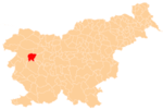
 Cerkljanski Vrh Location in Slovenia | |
| Coordinates: 46°6′26.99″N 14°0′7.65″E / 46.1074972°N 14.0021250°ECoordinates: 46°6′26.99″N 14°0′7.65″E / 46.1074972°N 14.0021250°E | |
| Country |
|
| Traditional region | Littoral |
| Statistical region | Gorizia |
| Municipality | Cerkno |
| Area | |
| • Total | 5.68 km2 (2.19 sq mi) |
| Elevation | 836.3 m (2,743.8 ft) |
| Population (2002) | |
| • Total | 76 |
| [1] | |
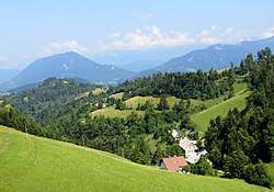
Cerkljanski Vrh (pronounced [tsɛɾˈkljaːnski ˈʋəɾx]) is a dispersed settlement in the hills south of Cerkno in the traditional Littoral region of Slovenia.[2] It includes the hamlets and isolated farms of Bende, Kacin, Krog, Zakrog, Hobovše (German: Hobousche bei Neuoßlitz[3]), Lajše, Mator, Na Ravan, Polanc, Stotnikar, Zakrog, and Za Vrhom.[4]
References
- ↑ Statistical Office of the Republic of Slovenia
- ↑ Cerkno municipal site
- ↑ Leksikon občin kraljestev in dežel zastopanih v državnem zboru, vol. 6: Kranjsko. Vienna: C. Kr. Dvorna in Državna Tiskarna. 1906. p. 58.
- ↑ Savnik, Roman (1968). Krajevni leksikon Slovenije, vol. 1. Ljubljana: Državna založba Slovenije. p. 67.
External links

- Cerkljanski Vrh at Geopedia
| Settlements | Administrative centre: Cerkno
|  | ||||
|---|---|---|---|---|---|---|
| Notable people |
| |||||
| Landmarks | ||||||
This article is issued from
Wikipedia.
The text is licensed under Creative Commons - Attribution - Sharealike.
Additional terms may apply for the media files.