Gipsy Hill
| Gipsy Hill | |
|---|---|
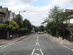 View of Gipsy Hill, looking north towards the City of London | |
 Gipsy Hill Gipsy Hill shown within Greater London | |
| Population | 13,712 (2011 Census. Ward)[1] |
| OS grid reference | TQ332710 |
| Ceremonial county | Greater London |
| Region | |
| Country | England |
| Sovereign state | United Kingdom |
| Post town | LONDON |
| Postcode district | SE19, SE27 |
| Dialling code | 020 |
| Police | Metropolitan |
| Fire | London |
| Ambulance | London |
| EU Parliament | London |
| UK Parliament | |
Gipsy Hill is an area in south London within the London Borough of Lambeth. It borders the London Boroughs of Southwark and Croydon.
About
Gipsy Hill is the name of the main road that runs in a southerly direction from Gipsy Road, near its junction with South Croxted Road, up to Westow Hill in Upper Norwood. It takes its name from the presence of Gipsies in what was a relatively remote rural area until Gipsy Hill railway station was opened in 1856. On 11 August 1668, Samuel Pepys recorded in his diary that his wife had visited "the gypsies at Lambeth"; they may well have been located in this area.[2]
Gipsy Hill is also a geographical expression for the hilly area in the south-eastern corner of Lambeth that is situated south of Gipsy Road and east of Salters Hill.
Gipsy Hill ward is represented by three elected members of Lambeth Borough Council and includes some areas that are often identified as parts of West Norwood and West Dulwich.
Gipsy Hill Police Station is located on a road named Central Hill about 50 m from the top of the one named Gipsy Hill. It is London's highest Metropolitan Police station. The area plays host to two independent brewing companies – the Gipsy Hill Brewing Co and the London Beer Factory.[3]
In Lunham Road there is a decommissioned nuclear bunker. The 18-room bunker was constructed between 1963 and 1966 as part of a block of flats on the Central Hill Estate called Pear Tree House.
Schools
- Elm Wood Primary School, Carnac Street.
- Kingswood Primary School, Gipsy Road (on two sites). Details of a series of reports on the school can be found in the relevant section of the Ofsted website.[4]
- Park Campus Academy, Gipsy Road.
- Paxton Primary School, Woodland Road. Details of a series of reports on the school can be found in the relevant section of the Ofsted website.[5]
Elm Wood, Kingswood and Paxton schools are all members of The Gipsy Hill Federation.[6]
There are no private schools in Gipsy Hill itself, but a number operate nearby in areas such as West Dulwich.
Churches
The following congregations meet in buildings that are readily identified as places of worship:
- Berridge Road Community Church (Anglican), Berridge Road, SE19 1EF[7]
- Christ Church, Gipsy Hill (Anglican), 1 Highland Road SE19 1DP[8]
- Kingdom Hall of Jehovah's Witnesses, Whiteley Road, SE19 1JT
- Upper Norwood Methodist Church, Westow Hill, SE19 1TQ[9]
These buildings were constructed as places of worship but are now used for other purposes:
- Former Gipsy Hill Wesleyan Chapel, 16 Gipsy Hill, SE19 1NL - converted into flats.
- Former Gipsy Road Baptist Church, 226 Gipsy Road, SE27 9RB - upper part converted into flats, ground floor used by a nursery.
Nearest places
Nearest stations
Notable residents
- Errol Brown of Hot Chocolate, lived in Alexandra Drive, Gipsy Hill
- Daniel Kitson, comedian, known for Phoenix Nights
- Nadia Sawalha, actress and television presenter
- Kate Thornton, former presenter of The X Factor
- Nathaniel Chalobah, Watford football player
- Martin Orbell, sound engineer for The Boomtown Rats and the Sex Pistols
- Krept & Konan, rappers
References
- ↑ "Lambeth Ward population 2011". Neighbourhood Statistics. Office for National Statistics. Retrieved 12 October 2016.
- ↑ "Tuesday 11 August 1668 (Pepys' Diary)". Pepysdiary.com. Retrieved 2013-08-18.
- ↑ "5 Places to Live in South London". UK Investor. Retrieved 2016-08-29.
- ↑ "Kingswood Primary School". Ofsted. Retrieved 2015-09-14.
- ↑ "Paxton Primary School". Ofsted. Retrieved 2015-09-14.
- ↑ "The Gipsy Hill Federation". Retrieved 2015-09-14.
- ↑ "Christ Church Gipsy Hill". Gipsyhill.org.uk. Retrieved 2013-08-18.
- ↑ "Christ Church Gipsy Hill". Gipsyhill.org.uk. Retrieved 2013-08-18.
- ↑ Balston, James (2012-12-07). "The Triangle SE19: Upper Norwood Methodist Church". Thetrianglese19.blogspot.co.uk. Retrieved 2013-08-18.
External links
| Districts | 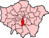 | |
|---|---|---|
| Attractions |
| |
| Bridges | ||
| Parks and open spaces |
| |
| Constituencies | ||
| Tube, rail, and riverboat stations | ||
| Other topics | ||