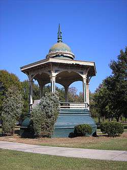
Central City Park Bandstand
|
Central City Park Bandstand | |
 | |
 | |
| Location | Central City Park, Macon, Georgia |
|---|---|
| Coordinates | 32°49′59″N 83°36′55″W / 32.83306°N 83.61528°WCoordinates: 32°49′59″N 83°36′55″W / 32.83306°N 83.61528°W |
| Area | less than one acre |
| Built | 1871 |
| Architectural style | Late Victorian, "Saracenic style" |
| NRHP reference # | 72000361[1] |
| Added to NRHP | March 16, 1972 |
The Central City Park Bandstand is a hexagonal bandstand in Central City Park in Macon, Georgia that was built in 1871. It was listed on the National Register of Historic Places on March 16, 1972. The bandstand is located at the eastern terminus of Riverside Drive in Central City Park.[2]
It has been noted to be similar to the top of the iconic octagonal house Longwood (also known as Nutt's Folly) in Natchez, Mississippi.[2]
See also
References
- ↑ National Park Service (2010-07-09). "National Register Information System". National Register of Historic Places. National Park Service.
- 1 2 John J. McKay, Jr. (March 1971). "National Register of Historic Places Inventory/Nomination: Central City Park Bandstand". National Park Service. Retrieved August 26, 2016. with 5 photos from 1871 to 1971
This article is issued from
Wikipedia.
The text is licensed under Creative Commons - Attribution - Sharealike.
Additional terms may apply for the media files.